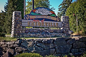
Eatonville (Washington)
| Eatonville | |
|---|---|
 |
|
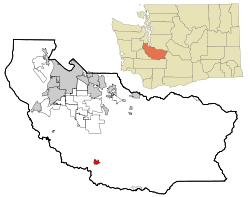
| Location in county and state Washington | |
| Basic data | |
| Foundation : | 1909 |
| State : | United States |
| State : | Washington |
| County : | Pierce County |
| Coordinates : | 46 ° 52 ′ N , 122 ° 16 ′ W |
| Time zone : | Pacific ( UTC − 8 / −7 ) |
| Residents : | 2,758 (as of 2010) |
| Population density : | 585.6 inhabitants per km 2 |
| Area : | 4.77 km 2 (approx. 2 mi 2 ) of which 4.71 km 2 (approx. 2 mi 2 ) is land |
| Height : | 245 m |
| Postal code : | 98328 |
| Area code : | +1 360 |
| FIPS : | 53-20260 |
| GNIS ID : | 1519161 |
| Website : | www.eatonville-wa.gov |
| Mayor : | Mike Schaub |
 |
|
Eatonville is a city in Pierce County in the US state of Washington , United States , with 2758 inhabitants (as of 2010).
geography
The place is about 83 km south of Seattle and about 44 km southeast of Tacoma . Eatonville is located on the western edge of the Cascade Mountains , Mount Rainier is only 38.5 km away.
Eatonville has an area of 4.77 km² (1.84 mi²).
climate
The annual average temperature is 15.1 ° C. The warmest month is July with an average of 24.3 ° C, the coldest is January with −1.5 ° C.
Over the course of a year, an average of 1153 mm of precipitation falls.
|
Average monthly temperatures and rainfall for Eatonville
Source: Weatherbase.com, (1980-2017)
|
|||||||||||||||||||||||||||||||||||||||||||||||||||||||||||||||||||||||||||
history
The area around what is now Eatonville was originally populated by the Nisqually Indians .
The first white settlers settled in this area around 1851. The city was officially founded in 1909. The city was named after Thomas Cobb Van Eaton, one of the early settlers.
The following table shows the historical population development of Eatonville:
| year | Residents | year | Residents | year | Residents | ||
|---|---|---|---|---|---|---|---|
| 1910 | 754 | 1950 | 1048 | 1990 | 1374 | ||
| 1920 | 861 | 1960 | 896 | 2000 | 2012 | ||
| 1930 | 912 | 1970 | 852 | 2010 | 2758 | ||
| 1940 | 996 | 1980 | 998 | 2020 |
administration
Mayor Mike Schaub has been in charge of Eatonville's administration since 2014. The mayor and the five city council members who support him are elected for a term of four years.
Demographics
On April 1, 2010, Eatonville was home to 2,758 people, of whom 1,431 (51.9%) were women and 1,327 (48.1%) were men.
71.3% of the population lived in their own house or in their own apartment and only 28.7% rented them.
Information on the age structure of the residents is given in the following table:
| population | Residents | proportion of | population | Residents | proportion of | |
|---|---|---|---|---|---|---|
| under 18 years | 838 | 30.38% | 35 - 49 years | 550 | 19.94% | |
| 18-24 years | 210 | 7.61% | 50 - 64 years | 462 | 16.75% | |
| 25 - 34 years | 351 | 12.73% | over 64 years | 347 | 12.58% |
traffic
Eatonville has had a small airport, Swanson Airport , since 1952 .
The nearest major commercial airport is Seattle-Tacoma International Airport, approximately 65 km north of the city center .
Culture and sights
The Eatonville Arts Festival takes place annually on the first weekend in August , an event with a handicraft market, music, dance and theater performances.
The Pioneer Farm Museum is about 6 km to the west of the city center . An open-air museum that offers insights into the way of life of the early settlers and the local indigenous people .
The nearby Mount Rainier National Park can be reached from Eatonville in about 30 minutes by car.
Web links
- Website Pioneer Farm Museum (English)
- Website of the local newspaper The Dispatch (English)
Individual evidence
- ↑ a b EATONVILLE, WASHINGTON. weatherbase.com, accessed February 14, 2018 .
- ^ Early Eatonville. Abbi Wonacott, June 19, 2011, accessed February 14, 2018 .
- ↑ Schaub running for second term as mayor. The Dispatch, May 5, 2017, accessed February 14, 2018 .
- ↑ 2010 Census Interactive Population Search. (No longer available online.) United States Census Bureau, formerly the original ; accessed on February 14, 2018 (English). ( Page no longer available , search in web archives ) Info: The link was automatically marked as defective. Please check the link according to the instructions and then remove this notice.
- ↑ 2W3-Swanson Airport, Eatonville, Washington, USA. airnav.com, accessed February 14, 2018 .
