Edmonton Capital Region
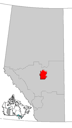
The Edmonton Capital Region (ECR), often also called Alberta Capital Region, Greater Edmonton or Metro Edmonton, is a metropolitan area around the city of Edmonton , the provincial capital of Alberta . It is one of the six regions in the province.
The ECR are usually based on the Edmonton census area. There are, however, different boundaries drawn for different administrative tasks. The ECR is the northernmost metropolitan area in Canada and is located in the heart of Alberta. It forms the northern end of the Calgary-Edmonton Corridor , one of Canada's four largest economic regions, which is home to half of Canada's population.
geography
| Central Alberta | ||
| Central Alberta |

|
Central Alberta |
| Central Alberta |
The region is completely enclosed by the Central Alberta region.
Edmonton Metropolitan Area (Edmonton CMA)
The Edmonton CMA includes the following 35 communities:
- five Cities ( Edmonton , Fort Saskatchewan , Leduc , St. Albert , and Spruce Grove );
- a special parish ( Strathcona County ), which includes the parish of Sherwood Park ;
- three parishes ( Leduc Counties , Parkland Counties, and Sturgeon Counties );
- 10 Towns ( Beaumont , Bon Accord , Bruderheim , Calmar, Devon, Gibbons, Legal, Morinville, Redwater, and Stony Plain);
- five villages (New Sarepta, Spring Lake , Thorsby, Wabamun, and Warburg);
- eight summer villages (Betula Beach, Golden Days, Itaska Beach, Kapasiwin, Lakeview, Point Alison, Seba Beach and Sundance Beach); and
- three First Nations (Alexander First Nation or Alexander IR No. 134, Enoch Cree Nation # 440 or Stony Plain IR No. 135 and Paul First Nation or Wabamun IR No. 133A and 133B).
Contrary to popular belief there, (western parts of) Lamont County and Elk Island National Park are not part of the Edmonton CMA. Only after the division of the traffic connections by the provincial government does Lamont County belong to the CMA.
The total area of the Edmonton CMA is 9418 km². Edmonton CMA is the largest urban area in Canada. The population was based on the 2006 Canadian Census at 1,034,945.
Former parishes
Edmonton parish of three previous parishes: Beverly in 1961 , Jasper Place in 1964 and Strathcona in 1912 .
Regional population
| CMA Municipality | population | Year |
|---|---|---|
| Cities | ||
| Edmonton | 782.439 | 2009 |
| Fort Saskatchewan | 17,469 | 2009 |
| Leduc | 21,597 | 2009 |
| Spruce Grove | 23,326 | 2009 |
| St. Albert | 58.501 | 2008 |
| total | 903.332 | |
| Towns | ||
| Beaumont | 11,794 | 2009 |
| Bon Accord | 1,534 | 2006 |
| Brother home | 1,215 | 2006 |
| Calmar | 2,033 | 2009 |
| Devon | 6,534 | 2009 |
| Gibbons | 2,848 | 2007 |
| Legal | 1,192 | 2006 |
| Morinville | 7,636 | 2009 |
| Redwater | 2,192 | 2006 |
| Stony Plain | 12,363 | 2006 |
| total | 49,341 | |
| Villages | ||
| New Sarepta | 530 | 2009 |
| Spring Lake | 592 | 2007 |
| Thorsby | 945 | 2006 |
| Wabamun | 662 | 2009 |
| Warburg | 696 | 2009 |
| total | 3,425 | |
| Summer villages | ||
| Betula Beach | 15th | 2006 |
| Golden Days | 207 | 2006 |
| Itaska Beach | 35 | 2006 |
| Kapasiwin | 15th | 2009 |
| Lakeview | 36 | 2006 |
| Point Alison | 4th | 2008 |
| Seba Beach | 203 | 2006 |
| Sundance Beach | 102 | 2006 |
| total | 617 | |
| Municipal Districts | ||
| Leduc County | 12,730 | 2006 |
| Parkland County | 30,089 | 2009 |
| Sturgeon County | 19,165 | 2008 |
| total | 61,984 | |
| Specialized Municipalities | ||
| Strathcona County | 87,998 | 2009 |
| total | 87,998 | |
| First Nations Reserves | ||
| Alexander 134 or Alexander First Nation | 989 | 2008 |
| Stony Plain 135 or Enoch Cree Nation # 440 | 1,525 | 2008 |
| Paul First Nation | 1,277 | 2008 |
| total | 3,791 | |
| Total | 1,110,488 |
Including the population of Lamont (1,664) and Lamont County (3,925, both 2006) and subtracting the population of Spring Lakes, the eight Summer Villages and the three First Nations, the population is 1,111,077.
See also
Web links
Individual evidence
- ^ Population and dwelling counts for the Edmonton CMA . Statistics Canada . March 17, 2007. Retrieved December 24, 2009.
- ↑ a b Alberta 2009 Official Population List (PDF; 258 kB) Alberta Municipal Affairs . Retrieved December 24, 2009.
- ↑ Strathcona County's 2009 population of 87,998 includes 61,660 in Sherwood Park urban area and 26,338 in rural area.


