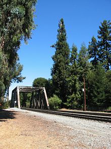
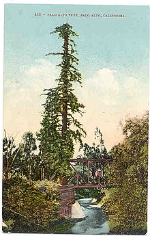
El Palo Alto
El Palo Alto is a coastal redwood ( Sequoia sempervirens ) that is found in El Palo Alto Park on the banks of San Francisquito Creek in Palo Alto , California , United States . El Palo Alto means , roughly translated, the tall tree in Spanish .
El Palo Alto is 110 feet (33.5 meters) high (compared to 134.6 feet or 41 meters in 1951), 90 inches (2.3 meters) in diameter and a crown with a wingspan of 40 feet (12 meters).
The tree is California's No. 2 Historic Landmark (Number 1 is the Monterey Customs House ). It is a tree frequently visited by the Costanoan / Ohlone Indians because of its historical importance as "the camp for the participants of the Portola Expedition of 1769" and because of its use as a viewing tree for surveyors by the National Arborist Association and the International Arboriculture Society who measure the El Camino Real recognized. The tree is featured on the official seal of the City of Palo Alto and the seal of Stanford University . It is believed to be the origin of the city's name.
The tree dates from around 940 and is said to be healthier today than it was 100 years ago. El Palo Alto originally had a double trunk, but a flood on San Francisquito Creek in 1887 tore off one of the two tribes.
A decorative plate on the tree base bears the following inscription:
" Under this tall redwood tree, the Palo Alto, remotely accessed from 6. November bis 11. November , 1729 Portola and his men on the expedition, in which the San Francisco Bay was discovered. It was the meeting point for their reconnaissance departments. Here, in 1774, Padre Palou erected a cross to mark the place for a planned mission (which was later built in Santa Clara). Pedro Font's famous 1776 topographic map contained the drawing of the original double-stemmed tree that made the Palo Alto the official living symbol of California. "
Individual evidence
- ↑ City of Palo Alto. El Palo Alto Historic Report (PDF)
Web links
- City of Palo Alto's Heritage Trees
- Stanford University History: Prologue
- Historic photos of San Francisquito Creek, including El Palo Alto
- City Arborist Report, 1999 (PDF file; 223 kB)
Coordinates: 37 ° 26 '50.2 " N , 122 ° 10' 12.5" W.

