
Elwood (Victoria)
| Elwood | |||||||||
|---|---|---|---|---|---|---|---|---|---|
 Elwood Beach |
|||||||||
|
|||||||||
|
|||||||||
|
|||||||||
|
|||||||||
|
|||||||||

Elwood is a district of Port Phillip City in Greater Melbourne , Australia , about 7 km southeast of the Central Business District. Elwood is a popular destination during the summer months due to its beaches.
Parks and green spaces
Despite the density of buildings, Elwood is a very green district. The most popular and largest green spaces are on the water, including Elwood Beach , Elwood Canal, and Point Ormond Reserve .
However, Elwood is not free from environmental problems. The beach and canal are often polluted by rubbish, and the canal often has a distinctive smell due to the backflow of seaweed. However, the local administration has developed strategies to solve these problems.
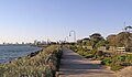
Elwood Beach and Melbourne's Skyline
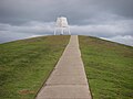
Point Ormond

Elsternwick Park


Street names
South of Ormond Road, many streets are named for things related to the beach: for example Beach Avenue, Spray Street, Wave Street (wave), Tide Street (tide), and Foam Street (foam). North of Ormond Road, the streets bear the names of famous writers and poets such as Shakespeare Grove, Dickens Street, Milton Street, Wordsworth Street, Byron Street, Keats Street, Tennyson Street, Ruskin Street and Shelley Street.
Web links
Individual evidence
- ↑ Australian Bureau of Statistics : Elwood ( English ) In: 2016 Census QuickStats . June 27, 2017. Retrieved April 20, 2020.