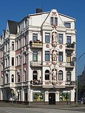
Rudelsburg ensemble
The residential and commercial building Ensemble Rudelsburg in Bremerhaven - Lehe , district Goethestrasse, Goethestrasse 1 and 3, was built in 1899 according to plans by building contractor Heinrich Kistner from Lehe.
The building has been a listed building in Bremen since 1980 .
history
Around 1900, Lehe expanded from Hafenstrasse in the direction of Goethestrasse and the imperial ports .
The four-storey, plastered tenement house with a penthouse and the wide, heavily decorated corner formation at Goethe and Pestalozzistraße 8 is a typical example of historicism buildings . Several bay windows are part of the design of the corner house. The three larger-than-life figures on the gable, arranged one above the other, are intended to represent science, trade and industry. The client was the stucco company Brüggemann.
The Rudelsburg was on the ground floor on the corner of Pestalozzistraße before and during the Nazi era it was the SA club . In 1930/31, violent disputes took place here between the then still social-revolutionary SA, which was under the influence of the Reich organizer of the NSDAP Gregor Strasser and his brother Otto Strasser , and the local party leadership, represented by Gauleiter Otto Telschow (NSDAP). The opposition members were expelled from the NSDAP in 1932.
The formerly popular Rudelsburg above Saaleck in Saxony-Anhalt could have given the building its name. Even today (2018) there is a restaurant ( music bar ) with a hall.
literature
- Harry Gabcke , Renate Gabcke, Herbert Körtge, Manfred Ernst: Bremerhaven in two centuries; Volumes I to III from 1827 to 1991 . Nordwestdeutsche Verlagsgesellschaft, Bremerhaven 1989/1991, ISBN 3-927857-00-9 , ISBN 3-927857-37-8 , ISBN 3-927857-22-X .
- Wolfgang Brönner: Bremerhaven. Architectural monuments of a port city , Bremen 1976.
- Hartmut Bickelmann : Between business development and residential construction. The southern Hafenstrasse and its catchment area up to the First World War . In: Bremerhaven Contributions to City History Vol. II, Bremerhaven 1996.
- Dehio Bremen / Lower Saxony 1992
Individual evidence
Coordinates: 53 ° 33 ′ 8.9 " N , 8 ° 34 ′ 48.4" E


