Altglienicke Evangelical Cemetery
The Evangelical Cemetery Altglienicke is located in the street Am Alten Friedhof No. 27-44 above Rudower Straße in Berlin's Treptow-Köpenick district, Altglienicke . The cemetery was laid out there in 1884, is managed by the Evangelical Parish Altglienicke and today covers an area of 19,169 m². The cemetery chapel from 1904/05, the surrounding wall with the hereditary burials and the entrance portal from 1905 are entered in the Berlin list of monuments.
Prehistory: Former cemeteries
The community, first mentioned in 1375 as Glinik , had for several centuries a cemetery around the village church (today's Altglienicke parish church ) as a burial place. Due to the location in the Berlin glacial valley , an area rich in swamps with a high groundwater level and floods that continued until the construction of the Teltow Canal , the site proved to be less suitable due to occasional buoyancy of coffins, so that a higher burial place was sought in the 18th century. This could be found close to the church, in view of the slope edge to the Teltow plateau , in today's Köpenicker Straße 33.
In 1764, colonists from the Palatinate were settled in Glienicke by Frederick the Great , who brought their Reformed , Calvinist beliefs with them to Brandenburg-Prussia and, as new Glienickers, received extensive independence from the Lutheran Alt-Glienickers. Since at that time registry office matters were in the hands of the church and cemeteries were strictly denominational, from now on, next to the Evangelical Lutheran cemetery of the Alt-Glienicker in today's Köpenicker Strasse 35, another Evangelical-Reformed cemetery of the Neu-Glienicker was built.
Due to the increased space requirements of the growing communities, both cemeteries were expanded several times until 1849, but in the following period they again reached the limit of their capacity. A further expansion in the town center was not possible. Finally, in 1884, a 1.7 hectare new burial site was laid out above Rudower Strasse on Hannemann's farmland, near the boundary of the district. The two old cemeteries on Köpenicker Straße were closed except for the possible continuation of existing hereditary burials . Since the new cemetery was administered exclusively by the Evangelical Lutheran congregation, the Reformed were also allowed to bury their deceased there, but had to pay a double grave fee or switch to the Evangelical Reformed cemetery in the nearby town of Cöpenick .
In 1893, by imperial order, the parishes of Alt-Glienicke and Neu-Glienicke were merged to form a unified parish of Altglienicke. From then on, uniform grave site fees for Reformed and Lutherans also apply in the new cemetery. In 1897 the parsonage of the Evangelical Parish was built on part of the Evangelical Reformed cemetery.
The remaining old cemetery was reactivated for individual burials during World War II . Many Red Army soldiers who died in 1945 were also buried here, until they were reburied in the following years at the Soviet Memorial in Treptower Park .
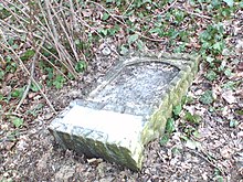
The area of the old cemetery that still remains today between the rectory and primary school on the mountain was overgrown by ivy and wild growth for a long time. A few remains of gravestones can still be found after the wild growth has been removed. A public green area with a children's playground is currently being built here.
Layout of the cemetery from 1884
The 1884 created new cemetery in the street at the old cemetery (name actually misleading, since the old cemetery in the Kopenickerstrasse was) received the land in 1904/05 in the middle of a running according to plans by F. Nischau and E. Schindler chapel , the Like the wrought iron gate designed by E. Markus in 1905 with the portal heading taken from the Old Testament ( Job 19:25), “I know that my Redeemer lives” is a listed building.
The surrounding wall with the individual hereditary burials is also entered in the list of historical monuments. Since the surviving dependents also had to take care of the corresponding section of the cemetery wall with the acquisition of a hereditary burial for their family, this has a changing appearance.
The oldest grave inscription still preserved today is the hereditary burial of the Dietz family from 1887 from the early days of the complex. In the northern area of the cemetery there are many very old graves that remind of important families and individual personalities of the Altglienick local history, some of whom were related to each other and by marriage: former landowners, pastors, business owners, architects, village school teachers or innkeepers. One of the outstanding tombs is that of the "community and school supervisors, patronage elders, district council members, district committee members and knights pp" Friedrich Hannemann (1831–1898), who as a village mayor shaped the development of Altglienicke for a long time. During his term of office, among other things, the construction of the parish church , the old school, the fire station and this very cemetery, for which he made the land that had been used for agriculture available.
Evangelical cemetery and municipal cemetery
In Altglienicke today a distinction has to be made between the Evangelical Cemetery, which is under church administration, and the Altglienicke Municipal Cemetery , which is under municipal administration of the Treptow-Köpenick District Office (Friedhofsamt) and is located a few kilometers south on Schönefelder Chaussee. The latter was built in 1911 as an extra-territorial cemetery for the evangelical community of Niederschöneweide . With the incorporation of Niederschöneweides and Altglienicke in 1920 in Greater Berlin , this was transferred to municipal sponsorship and from then on could also be used for Altglienicke deceased.
Web links
Coordinates: 52 ° 25 ′ 16 ″ N , 13 ° 31 ′ 43.3 ″ E


