Fürstenberg (Höingen)
| Furstenberg | ||
|---|---|---|
|
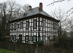
Former forester's house on the Fürstenberg |
||
| height | 279 m above sea level NN | |
| location | North Rhine-Westphalia , Germany | |
| Mountains | Sauerland | |
| Coordinates | 51 ° 28 '28 " N , 7 ° 57' 3" E | |
|
|
||
The Fürstenberg near Höingen in the Soest district in North Rhine-Westphalia is a 279 meter high elevation in the Sauerland .
There are prehistoric barrows on the eastern slope of the mountain . In the 8th century, Oldenburg Castle stood on Fürstenberg , a hill fort that served the local population as a refuge during the Saxon Wars .
The Fürstenberg Castle , a country castle Kurkölns , was first mentioned in 1295 and 1343/1344 completely destroyed. The mountain got its name after the episcopal prince elector and sovereign of the Duchy of Westphalia : the mountain of the prince - Fürstenberg. The Fürstenberg family named themselves after the castle . There is also a chapel on the mountain , the history of which dates back to the 15th century.
literature
- Bernhard Bahnschulte : What the Fürstenberg experienced in four thousand years. Neheim-Hüsten, 1955
- Johann Suibert Seibertz : The Fürstenberg . In: Non-profit house calendar for the administrative district Arnsberg Jg. 3.1822 digitized

