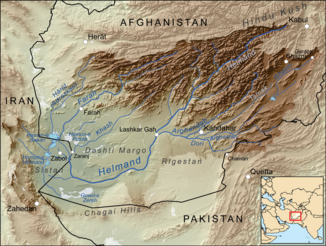
Farah Rud
| Farah Rud | ||
|
|
||
| Data | ||
| River system | Farah Rud | |
| source |
Band-e Bayan 33 ° 59 '32 " N , 65 ° 1' 15" O |
|
| muzzle | See Sabari ( Sistanbecken ) coordinates: 31 ° 29 '40 " N , 61 ° 22' 48" O 31 ° 29 '40 " N , 61 ° 22' 48" O
|
|
| length | 580 km | |
| Catchment area | approx. 33,000 km² | |
| Discharge at the Farah A Eo gauge : 26,700 km² |
MQ 1953/1960 Mq 1953/1960 |
48 m³ / s 1.8 l / (s km²) |
| Medium-sized cities | Farah | |
|
Course of the Farāh Rud (English Farah) |
||
The Farāh Rud (name from Persian ) is a river in western Afghanistan .
It rises on the southern foothills of the Band-e Bayan mountain range in the northeast of the Ghor province . It flows in a south-westerly direction. In the upper and middle reaches the river flows through the central Afghan mountains. In the lower reaches it leaves the mountains and flows through the desert landscape of the Farah province . He passes the oasis town of Farah . After about 580 km, the river reaches Lake Sabari, which has no outflow in the Sistan Basin , near the Afghan- Iranian border . The river is used for irrigation .
Individual evidence
- ↑ a b Article Farāh Rud in the Great Soviet Encyclopedia (BSE) , 3rd edition 1969–1978 (Russian)
- ↑ UNESCO ( Memento of March 4, 2016 in the Internet Archive )
