Farallon Islands
| Farallon Islands | ||
|---|---|---|
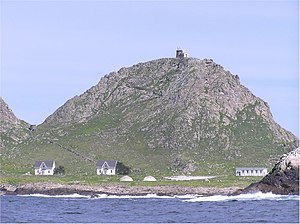
| Coast Guard and Research Station on Marine Terrace, with a lighthouse on the summit | ||
| Waters | Pacific Ocean | |
| Geographical location | 37 ° 44 ′ N , 123 ° 4 ′ W | |
|
|
||
| Main island | Southeast Farallon Island | |
| Total land area | 42 ha | |
| Residents | 3 | |
| South Farallon Islands (nautical chart 1957) | ||
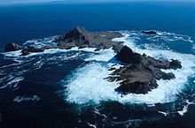
The Farallon Islands ( English Farallon Islands ) are a group of rugged volcanic islands and rocks in the Gulf of the Farallones, off the coast of San Francisco . They are 27 miles west of the Golden Gate and 20 miles south of Point Reyes . Administratively, they belong to the metropolitan area of San Francisco, namely District 1: Northwest (also called Richmond District).
geography
![]() Map with all coordinates of the geography section : OSM
Map with all coordinates of the geography section : OSM
The islands extend from Southeast Farallon Island , the largest island, for 8 km to the northwest. The total land area is 0.42 km².
| Block No. 1 |
Island (s) | Area (m²) |
height | Coordinates |
|---|---|---|---|---|
| 2000 | South Farallon Islands | 387,688 | 109 | 37 ° 42 ′ N , 123 ° 00 ′ W |
| 2001 | Middle Farallon Island | 3,362 | 6th | 37 ° 44 ' N , 123 ° 02' W. |
| 2002 | North Farallon Islands | 28,270 | 47 | 37 ° 46 ′ N , 123 ° 06 ′ W |
| - | Fanny Shoal | - | −4 | 37 ° 47 ' N , 123 ° 10' W. |
| 2999 2 | Farallon Islands | 419.320 | 109 | |
| 1 of Block Group 2, 604 Counting District , San Francisco | ||||
| 2 Block number of the territorial waters , with an area of 247,530,823 m² | ||||
South Farallon Islands
By far the largest part of the area (0.39 km²) is taken up by the southern Farallon Islands - especially Southeast Farallon Island and the Maintop Island (West End) immediately to the west, separated by the impassable Jordan Channel , which is only 5 meters wide . The highest point on Southeast Farallon Island is Tower Hill at 109 m. On the summit, flattened by workers, is the lighthouse , which was first erected there in 1853. A Coast Guard and Research Station is located on Marine Terrace just south of the summit. Other islands include Seal Rock , Aulone Island , Sugarloaf , Sea Lion Rock and the Drunk Uncle Islets .
Middle Farallon Island
Middle Farallon Island is about 3 km northwest of the southern islands, with a diameter of 65 meters and an area of only 3,362 m². The bare and guano- covered island is unofficially called The Pimple .
North Farallon Islands
Another 7 km northwest are the Northern Farallon Islands (area 0.03 km²). They consist of two groups of bare, steep rocks: A group around the Isle of St. James with three larger islands (around 100 meters in diameter) and four smaller rocks, and 700 meters northwest of North Farallon Island (160 meters from north to south , maximum 60 meters wide) with three smaller rocks in front (15 to 40 meters in diameter).
Official sources name four islands in the area of the North Farallon Islands:
- East Island
- South Iceland
- West Island (Isle of St. James)
- North Island
Fanny Shoal
The northwestern end of the group is marked by the Fanny Shoal bank located 5 km northwest of the North Farallon Islands , which is 3 km in diameter and less than 55 meters deep. The shallowest point is the Noonday Rock reef with a water depth of 4 m. One kilometer west of Noonday Rock is a floating beacon. The name Noonday Rock comes from a ship that ran aground here in 1862 and sank within an hour.
Benches northwest of Fanny Shoal
The banks northwest of Fanny Shoal are no longer part of the Farallon Islands and are outside of US territorial waters . 25 km northwest of Noonday Rock is the Cordell Bank National Marine Sanctuary , a significant and protected marine biotope . The Rittenburg Bank is located between Fanny Shoal and Cordell Bank at 37 ° 53 ′ N , 123 ° 18 ′ W , with a shallowest depth of less than 80 meters.
history
The islands have always been known to the Indians as the "islands of death", which one was not allowed to enter. In 1539 the navigator Juan Rodríguez Cabrillo discovered the islands while exploring the California coast and named them Farallones , which means something like "cliff" or "small pointed islands" in Spanish. In 1579 the English navigator Francis Drake landed on the islands first to collect provisions in the form of meat and bird eggs. He baptized them Islands of Saint James . This name of the archipelago has been preserved in the name of one of its rocks. In 1603 the Spaniard Sebastián Vizcaíno mapped the islands and took possession of them for Spain . In 1769 the Spanish navigator Juan Francisco de la Bodega y Quadra named the islands Los Frayles (“the brothers”) while exploring the Pacific coast of North America . However, this name did not catch on. The islands belonged to the Spanish viceroyalty of New Spain and from 1810/1821 to the now independent Mexico . In 1810, American hunters from Boston visited the islands to hunt seals. 1812–1841 the Russians from Fort Ross operated a seal-hunting station on the islands. It was the southernmost outpost of Russian America . In 1848 the Farallon Islands and Upper California came to the United States through the Treaty of Guadalupe Hidalgo . Because of the increasing shipping traffic in the Bay of San Francisco , a lighthouse was built on the islands in 1853 . In 1909 the islands were declared a bird sanctuary.
At the time of the Second World War , in addition to the US Coast Guard, there was also a small military outpost on the main island ( Southeast Farallon Island ). At that time over 50 people lived on this less than 0.5 km² island. Until 1969 there was a permanently manned post of the US Coast Guard on the island, which ensured a functioning lighthouse. When the 'Farallon Light' was automated, biologists from the research facility PRBO Conservation Science (then Point Reyes Bird Observatory) took over the monitoring of the islands and the recovering animal population there. 3 (in winter) to 8 (in summer) biologists are permanently on the Southeast Farallones , which is closed to visitors. Otherwise, the islands are uninhabited and are home to the largest colony of sea birds in the United States outside of Alaska . Among other things, the largest known colony of pigeon ducks is located here . There is also a large colony of elephant seals on the islands. In 1969, the Farallon National Wildlife and Wilderness Refuge was established to protect the islands .
Nuclear waste

The area surrounding the Farallon Islands is also known as the Farallon Island Nuclear Waste Dump because of the radioactive waste dumped at sea by the US Atomic Energy Commission between 1946 and 1970 . According to a report published by the United States Environmental Protection Agency (USEPA) in 1980 , approximately 47,500 containers and steel drums with contaminated waste were sunk in this archipelago between this time, but mainly before 1960, which caused the fishery and the protected area to reach approximately 14,500 Ci burden. The main deposit is located at the coordinates 37 ° 37 ′ N , 123 ° 17 ′ W at a depth of 1700 m, while approx. 3500 containers were sunk at 37 ° 38 ′ N , 123 ° 08 ′ W and today at a depth of 900 m lie. The San Francisco-based Naval Radiological Defense Laboratory is considered the primary user of this maritime dump because it was tasked with decontaminating atomic bomb test objects. Thus, among others, the aircraft carrier USS Independence (CVL 22) during the first two nuclear tests as part of Operation Crossroads served as the test vessel, different with radioactively contaminated materials customers, including the NRDL, loaded, and the end of January 1951 as the target vessel through the U.S. Navy sunk. According to the United States Geological Survey , the degree of exposure to the environment through nuclear waste and the exact location of each large container are unknown. On the advice of the USEPA, recovery of the waste from the seabed in order to then deposit it in special final storage facilities should not be carried out, as there would be too many risks for people and the immediate environment.
literature
- Peter White: The Farallon Islands, Sentinels of the Golden Gate , Scottwall Associates, San Francisco 1995, ISBN 0-942087-10-0 .
- Susan Casey: The Devils Teeth. A True Story of Obsession and Survival Among America's Great White Sharks , Henry Holt and Co., New York 2005, ISBN 0-8050-7581-X .
Individual evidence
- ↑ American Fact Finder
- ↑ US Fish and Wildlife Service: Farallon National Wildlife Refuge Final Comprehensive Conservation Plan and Environmental Assessment (PDF; 8.9 MB), page 51
- ↑ HOMeißner. I'm tsar in Alaska. P. 208.
- ^ The Columbia Lippincott Gazetteer of the World; Columbia University Press; 1962.
- ^ Anthony J. Gaston and Ian L. Jones: The Auks . Oxford University Press, Oxford 1998, ISBN 0-19-854032-9 , p. 179 and p. 180.
- ^ US Environmental Protection Agency: Radioactive waste dumping off the coast of California . 1980, p. 5 ( PDF, 412 kB ( memento of April 10, 2008 in the Internet Archive ) [accessed on September 20, 2007]).
- ^ Hunters Point Shipyard: Radiological Assessment . S. 6–30 ( PDF, 47.9 MB ( memento of February 18, 2012 in the Internet Archive ) [accessed on September 20, 2007]).
- ↑ Hunters Point Shipyard, pp. 6-24
- ↑ United States Geological Survey: Farallon Island Radioactive Waste Dump . ( Online ( Memento of May 16, 2014 in the Internet Archive ) [accessed on September 20, 2007]).
- ↑ US Environmental Protection Agency, p. 6.
Web links
- Farallon Island National Wildlife Refuge USFWS
- Farallon Islands - Article in the San Francisco Chronicle .
- Farallon Islands at the Center for Land use Interpretation
- Article about nuclear waste at the Farallons
- The Farallon Blog Weblog of the biologists working on the Farallon Islands


