
Federation Peak
| Federation Peak | ||
|---|---|---|
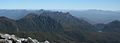
 Federation Peak from the eastern Arthur Range |
||
| height | 1224 m | |
| location | Tasmania | |
| Mountains | Arthur Range | |
| Coordinates | 43 ° 16 '17 " S , 146 ° 28' 32" E | |
|
||
| First ascent | January 27, 1949 by John Béchervaise | |
| particularities | most difficult mountain in Australia | |

The Federation Peak is an outstanding mountain in the southwest of the Australian state of Tasmania . The 1,224 m high mountain is located in Southwest National Park , about 90 km southwest of Hobart . It was named after the Federation of Australia (in 1901, English: Federation ) and is considered the most difficult mountain to climb in Australia.
history
Land surveyor James Sprent first mentioned the mountain he called The Obelisk in his account of his trigonometric survey of Tasmania. It then came to be known as Sprent's Obelisk , but in 1901 it was officially renamed Federation Peak after the Federation of Australia by Thomas Bather Moore , who built a route from Hastings to Port Davey through the Old River Valley .
In the nearly 50 years between the first sighting by Sprent and the first ascent, many daring adventurers tried to climb it. The dense, horizontal bars of scrub and the cool, temperate primary rainforest typical of the area turned out to be decisive obstacles. Then there was the often harsh weather of the Roaring Forties . It is testament to the savagery of the Tasmanian Southwest that it took nearly 50 years to reach its heart and gem.
After several unsuccessful attempts by various groups in the late 1940s, a game of the Geelong College Exploration Society under the leadership of John Béchervaise reached its peak on January 27, 1949.
The exposed and technically difficult normal path, which is normally walked without the aid of ropes, has already claimed a number of human lives, most recently on April 8, 2007, when a hiker fell fatally while descending the summit. He was dead on the spot.
climate
In the summit area of the mountain, high alpine conditions prevail, where the main weather phenomenon is the wind. Federation Peak is deeply snowed in late autumn, winter and early spring. Even in summer there is often heavy snowfall, even if the snow rarely remains.
Via ferratas

There are a number of difficult climbing routes to the summit, especially the Blade Ridge (grade 18), a sharp knife edge that swings out of the rainforest at the foot of the mountain. The edge merges into the main flank of the mountain a few hundred meters below the summit. The path then leads from the end of the ridge up an exposed but well-insured rock face approx. 600 m above the valley floor.
Most hikers with little or no climbing experience choose the exposed normal route from the southern traverse of the mountain above the 600 m drop above Lake Geeves.
The mountain can be reached from Geeveston either via Farmhouse Creek and Moss Ridge or from Scotts Peak via the eastern Arthur Range . The former is the shorter route and usually takes three days to complete. The route over Scotts Peak Dam and Arthur Range to Farmhouse Creek takes seven days, although in bad weather it can be up to 10 days.
Gallery images

Federation Peak from afar from Farmhouse Creek
Western Arthur Range from the summit of Federation Peak

Web links
Individual evidence
- ↑ a b Kevin Doran: Federation: Australia's Adventure Peak . Desdichado, 2004, ISBN 0-9586935-1-X , pp. 14-16.
- ^ Federation Peak death under investigation . In: Online News , Australian Broadcasting Corporation, April 9, 2007. Retrieved January 11, 2011.
- ↑ Ex-Buninyong man falls to his death , The Courier. April 11, 2007. Retrieved January 11, 2011.