
Narajow – Lany – Dunajow light railway
| Narajow – Lany – Dunajow | |||||||||||||
|---|---|---|---|---|---|---|---|---|---|---|---|---|---|
.jpg)
Narajow – Lany – Dunajow light rail passenger car
| |||||||||||||
| Route length: | approx. 100 km | ||||||||||||
| Gauge : | 700 mm | ||||||||||||
|
|||||||||||||
.jpg)
The light railway Narajow-Lany-Dunajow was during the First World War by the Austro-Hungarian land forces moved and as a horse course operated military field railway with 700 mm gauge in today's Ukraine .
purpose
After the battle of Gorlice-Tarnów in the war year 1916 , the approximately 100 km long field railway was mainly used to transport guns , supplies and ammunition .
Route
In Dunajiw there was a station south of the town center on the broad gauge - railway Pidhaitsi-Lviv where only the building materials and later the assets were transferred to the light railway.
A section of the line built in December 1916 led in a north-easterly direction from Dunajiw to Pomoryany .
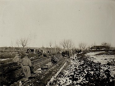
Construction of the Pomorzany - Dunajow light railroad , December 12, 1916
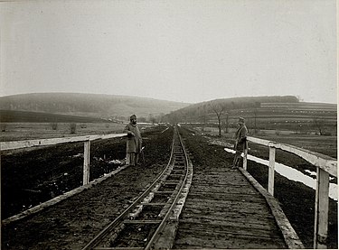
Light rail bridge on the Pomorzany – Dunajow line, Dec. 12, 1916
.jpg)
.jpg)
Ukrainian, Russian and Polish names of the light rail stations
- Pomorjany (Ukrainian Поморяни ; Russian Поморяны , Polish Pomorzany )
- Dunajiw (Ukrainian Дунаїв ; Russian Дунаев / Dunajew , Polish Dunajów ).
- Narajiw (Ukrainian Нараїв ; Russian Нараев / Narajew , Polish Narajów )
See also
- Lokomotivfeldbahn Ozydow – Monasztyrek
- Załośce – Zborów horse-drawn railway
- Varannó – Kelcse light railway
- Tryńcza light railway
Web links
Individual evidence
- ↑ Mauro Bottegal: Ferrovie portatili della Prima Guerra Mondiale. P. 71.
Coordinates: 49 ° 37 ′ 0 ″ N , 24 ° 49 ′ 25 ″ E