
Załośce – Zborów horse-drawn railway
| Załośce – Zborów horse-drawn railway | |||||||||||||||||||||||||||||||||
|---|---|---|---|---|---|---|---|---|---|---|---|---|---|---|---|---|---|---|---|---|---|---|---|---|---|---|---|---|---|---|---|---|---|
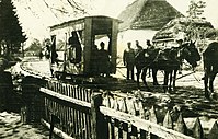
![Horse field railway Załośce – Zborów, 1917 [1]](https://de.wikipedia.org/wiki/Datei:Feldbahn_Za%C5%82o%C5%9Bce%E2%80%93Zbor%C3%B3w._Aus_Osman_und_Thomas;_%27IR._94%27_(Heimat-S%C3%B6hne,_Reichenberg).png) Załośce – Zborów horse-drawn railway, 1917
| |||||||||||||||||||||||||||||||||
| Route length: | 25 km | ||||||||||||||||||||||||||||||||
| Gauge : | 700 mm | ||||||||||||||||||||||||||||||||
|
|||||||||||||||||||||||||||||||||
The horse field railway Załośce – Zborów was a 1916–1917 during the First World War laid and operated by the Austro-Hungarian land forces , about 25 km long military field railway with 700 mm gauge in today's Ukrainian Ternopil Oblast .
history
Route
The route led on the eastern front from Saliszi (Załośce) to Sboriw (Zborów). It was probably connected as a branch line to the Ozydow – Monasztyrek locomotive field railway.
Transport volume
On March 21, 1916, more than 100 sick people were supposed to be transported away with the field train, although the eight "Krankverschubfeldbahnwagen" could only transport a total of 60 sick and wounded people. Because the transport with the field railway was not yet feasible and because of the impassability of the roads, the sick people were transported from Olejow with carts instead of the ambulance cars.
On May 5, 1916, two pairs of horses were used to transport two tons of coal on the field railway from Feldspital 2/14 to the field steam laundry in Olejow.
On June 10, 1916, due to the Brusilov offensive suffered further north, a disinfector and the building materials from the bathing establishment in Zaloce were brought to the light railroad to be transported from there.
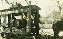
Push-off field railroad car
Push-off field railroad car

Horse-drawn railway carriage at Olejow


See also
- Lokomotivfeldbahn Ozydow – Monasztyrek
- Narajow – Lany – Dunajow light railway
- Varannó – Kelcse light railway
- Tryńcza light railway
Web links
Individual evidence
- ↑ Osman and Thomas: IR. 94. Homeland Sons, Reichenberg. Reproduced in: Hugo Schaefer: Österreichs Volksbuch vom WWII. Schubert, 1934. p. 349.
- ↑ Map of the villages and hospitals connected by the horse-drawn tram.
- ↑ "1. World War & Medicine “: Feldspital 2/14 in Olejow (Galicia) Part II (11). October 8, 2014. Retrieved February 5, 2020.
- ↑ a b "1. World War & Medicine “: Feldspital 2/14 in Olejow (Galicia) Part III (12). October 15, 2014. Retrieved February 5, 2020.
Coordinates: 49 ° 45 ′ 12.1 ″ N , 25 ° 1 ′ 31.5 ″ E