Fjallsárlón
| Fjallsárlón | ||
|---|---|---|

|
||
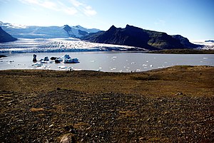
| View of Fjallsárlón with Fjallsjökull in the background | ||
| Geographical location | Iceland | |
| Tributaries | Breiðá from Breiðárlón | |
| Drain | Fjallsá to the Atlantic | |
| Data | ||
| Coordinates | 64 ° 1 '7 " N , 16 ° 23' 6" W | |
|
|
||
Fjallsárlón is a glacial lake at the southern end of the Icelandic glacier Vatnajökull .
It is located about 25 km east of Skaftafell National Park near the better known lake Jökulsárlón on Breiðamerkursandur in Hornafjörður municipality .
It is connected to the Breiðárlón by the Breiðá river . Above the lake is the Öræfajökull volcano , but its highest peak, Hvannadalshnúkur, can not be seen from the lake. From Öræfajökull, its outlet glacier, Fjallsjökull, extends down to the lake into which its glacier tongue calves . The icebergs here, however, are smaller than in Jökulsárlón.
In June, the large skuas nest on its rather quiet shores, and hikers should beware of them.
On June 25, 2017, Environment Minister Björt Ólafsdóttir placed part of the Fjallsárlón under protection and, together with the Jökulsárlón and part of the Breiðamerkursandur, now belongs to the Vatnajökull National Park .
See also
Individual evidence
- ↑ Jökulsárlón friðlýst: Óttast ekki málsókn ( Icelandic ) July 25, 2017. Retrieved July 26, 2017.
Web links
- Fjallsárlón website
- Map, pictures at Voyage en Islande ( Memento from December 18, 2012 in the web archive archive.today ) (French)
