Ditch
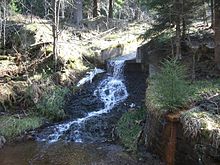
The dam ditch is the longest man-made ditch in the Upper Harz . Its purpose was to divert surface water for the operation of the Upper Harz coal and steel industry from distant areas with high levels of precipitation (in particular from the Bruchberg massif and parts of the Brocken massif). It was laid out from 1732 and extended further and further east until 1827. Its original total length was about 25 km; This could be successively shortened to about 19 km by building underground sections, so-called watercourses , in the years 1820 to 1861. It is a central part of the Upper Harz water shelf . It takes its name from the Sperberhaier Dam , which bridges a depression in the terrain.
history
The history of the dam trench is closely related to the history of the Sperberhaier dam. Only with its completion in 1734 could more productive waters east of Clausthal be developed with the Great and Small Gerlachsbach. In the years that followed, the Dammgraben was lengthened further and further eastwards: The first lengthening took place in 1736 as far as the Kleine Oker. In 1742, the Morgenbrodstaler Graben was built , diverting the Große and Kleine Söse to the Dammgraben. In 1774 it was extended to the so-called cradle of the Dammgraben, and in 1820, after the two Kellwasser watercourses and the Blochschleifegraben, the Kellwasser and Blochschleife could be connected to the Dammgraben system. The last expansion took place in 1827 when, with the construction of the Clausthaler flood ditch, the Flörichshaier ditch and the excavation, further drains in the east of the Bruchberg and in the west of the Brocken could be made usable for the Upper Harz mining. A further extension would have been possible, but was no longer discussed. An attempt was now made to master the energy problem in the Upper Harz mining industry more fundamentally by building deeper water solution tunnels ( Ernst August tunnels ). In addition, from the second half of the 19th century, other forms of energy (steam engine) were used, initially in addition to water power.
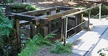
In the middle of the 19th century, however, the 10 km long section between Sperberhaier Damm and Clausthal was optimized: By creating watercourses (water transfer tunnels), several mountain bypasses of the ditch could be significantly shortened. In addition to clear advantages in terms of entertainment and winter operation, the increase in the gradient (shorter distance with the same height difference) and thus also the hydraulic performance were important. These Upper Harz watercourses , built around 1850, include the Rothenberg watercourse, the Coventhaier watercourse, the Neue Dietrichsberg watercourse and the Bielenwieser watercourse.
On average, the dam ditch was able to conduct up to 13 million cubic meters of water per year via the Sperberhaier Dam onto the Clausthal plateau. It was therefore considered to be one of the most important lifelines of the Upper Harz mining industry.
After mining was shut down, the dam ditch was used to generate electricity in Clausthal's Kaiser Wilhelm shaft until around 1976 . Since 1976, the water from the Dammgraben has been fed via the Mönchstal valley, which begins at its end, to the Okertalsperre , where it also drives turbines to generate electricity and can then be made available for the drinking water supply (by the Harz waterworks ).
The drinking water supply of the mountain town Altenau from the dam ditch was given up around the year 2000, because the water supply was very uncertain, especially in severe winters, and the water quality was very changeable. Today the operator of the dam ditch is Harzwasserwerke GmbH.
Catchment area
The dam ditch draws its water from a total of six Harz rivers:
- Söse over the Morgenbrodstaler Graben (1715–1718; length 3,970 m)
- Sieber over the Clausthaler Flutgraben (also called Rotenbeeker Graben) (1797; length 3,900 m)
- Or over the Clausthaler Flutgraben and the Flörichshaier Graben (1826; length 1,050 m)
- Ecker over the Abbegraben (1827; length 1,540 m)
- Radau over the excavation
- Oker over the dam ditch (1725–1840; length 14,690 m)
The dam trench system thus overcomes several watersheds .
Numbers and orders of magnitude
In total, the dam ditch is 19 km long in its current state. Of these, 15.4 km are open trenches and 3.6 km are underground watercourses (water transfer tunnels). Depending on the counting method, its associated ditch system can be assigned a total length of up to 49 km. In doing so, it only overcomes a height difference of around 60 m over most of the route. Its maximum volume flow is around 1 m³ / s.
Others
The Harz Hexenstieg , which leads from Osterode to Thale , runs along the dam ditch .
literature
- Martin Schmidt : The water management of the Upper Harz mining (= publication series of the Frontinus Society. Issue 13) . 3rd supplemented edition. Harzwasserwerke, Hildesheim 2002, ISBN 3-00-009609-4 .
- Martin Schmidt: WasserWanderWege, a guide through the Upper Harz water shelf - world cultural heritage . Ed .: Harzwasserwerke GmbH. 4th edition. Papierflieger Verlag, Clausthal-Zellerfeld 2012, ISBN 978-3-86948-200-2 .
Web links
- The dam ditch. Retrieved February 25, 2009 .
- The Upper Harz Water Shelf, the most important pre-industrial energy generation and energy supply system in the world. (PDF; 2.78 MB) Harzwasserwerke, accessed on July 24, 2017 .
Coordinates: 51 ° 48 ′ 6 ″ N , 10 ° 31 ′ 6 ″ E


