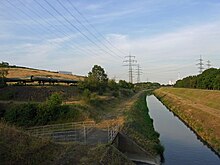
Fleithe
The Fleithe was an approximately 6.6 kilometers long tributary of the Emscher . It branched off from the main river south of today's Recklinghausen - Hochlarmark . Immediately after the division, the Grullbach flows from the right into the Fleithe from the north. It flowed for about 6 kilometers to the north, parallel to the main river, after about three kilometers it took in the water of the Resser Bach , which flows in from the north , today the Schellenbruchgraben , turned south after the confluence of the Holzbach and joined where the port of Grimberg is today of the Rhine-Herne Canal begins, again with the historic Emscher.
From a position north of the historic Koop farm, which is now the coal storage area of the Herne power plant , to the confluence of the Holzbach near Grimberg, the Emscher now follows the course of the Fleithe. In the bed of the former main river, the Rhine-Herne Canal was laid out in parallel. The north-south section of the Fleithe has fallen dry. The river bed is still geomorphologically recognizable, the vegetation shows increased soil moisture. The listed Fleuthebrücke of the Gahlener Kohlenweg from 1853 spans this former section of the river. Fleithe and Emscher border the nature reserve Resser Wäldchen .
The Fleithe formed the historical border between the Grafschaft Mark and Vest Recklinghausen. The city limits between the Herne districts of Crange and Unser Fritz in the south, as well as Recklinghausen- Hochlarmark , Herten and the Gelsenkirchen district of Resser Mark in the north still largely follow the historical, curved course of the Fleithe.
Historically, the names Flänte Bach and Fleuthe also existed for the Fleithe in the 19th century . In a border description from 1553/54 it was called Fleete . For the etymology compare Low German fleten , fleiten = flow .
Individual evidence
- ↑ a b c d Topographical Information Management, Cologne District Government, Department GEObasis NRW ( information )
- ↑ a b Manfred Hildebrandt [arrangement]: Herne - from Ackerstraße to Zur-Nieden-Straße: City history in the mirror of street names (Publications of the Herne City Archives; Volume 1), Ed .: Stadt Herne, Der Oberbürgermeister, Herne 1997; Entry: Fleithestrasse
- ↑ flow. In: Jacob Grimm , Wilhelm Grimm (Hrsg.): German dictionary . 16 volumes in 32 sub-volumes, 1854–1960. S. Hirzel, Leipzig ( woerterbuchnetz.de ).
Coordinates: 51 ° 32 ′ 55.1 ″ N , 7 ° 7 ′ 21.5 ″ E

