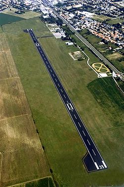
Foligno airport
| Aeroporto di Foligno | |
|---|---|

|
|
| Characteristics | |
| ICAO code | LIAF |
| Coordinates | |
| Height above MSL | 222 m (728 ft ) |
| Transport links | |
| Distance from the city center | 2 km south of Foligno , 25 km north of Spoleto , 110 km north of Rome |
| Basic data | |
| opening | approx. 1927 (asphalt railway 2006) |
| operator | ENAC |
| surface | approx. 160 ha |
| Passengers | approx. 3800 (2003) |
| Runways | |
| 17/35 | 1660 m × 30 m asphalt |
| 17GLD / 35GLD | 1100 m × 30 m grass |
The Foligno Airport (also Foligno-Sant'Eraclio , Foligno-Sterpete or Foligno-Spoleto ) is the airport of the Italian city of Foligno in the region Umbria . In contrast to the neighboring Perugia airport , it is not a commercial airport. The airport is the center of the air fleet of the national civil defense , here there are facilities for pilot training, it is used by the aviation industry based in Foligno and also some charter, cheap and transport flights start from here.
history
The origins of Foligno Airport go back to the dawn of aviation. At the end of the 1880s, a military air show with hot air balloons took place here in front of 50,000 people and in the presence of King Umberto I. The first aircraft flew here at the beginning of the 20th century. From 1927 to 1934, Foligno was served by passenger planes on the Rome-Venice-Vienna route. In the following years schools for pilot training and more and more military structures were built here. In the 1950s, the Rome-Foligno-Ancona passenger airline started operating for a short time. In the following years the Aeroclub Foligno was founded, which started a flourishing flight school. In the 1990s the airport became a center of Italian civil defense.