
Fort Frederik
| Fort Frederik | |||
|---|---|---|---|
| National Register of Historic Places | |||
| National Historic Landmark | |||
 Fort Frederik (seaward view) |
|||
|
|||
| location | North of the confluence of Lagoon Road and King Street, Frederiksted , Saint Croix (US Virgin Islands) | ||
| Coordinates | 17 ° 42 '54.9 " N , 64 ° 53' 0.4" W | ||
| surface | 8100 m² | ||
| Built | 1752 to 1760 | ||
| Architectural style | Colonial style | ||
| NRHP number | 96001073 | ||
| The NRHP added | 1976 | ||
| Declared as an NHL | 1997 | ||

Fort Frederik , also known as Frederiksfort , is a former fortress in Frederiksted , Saint Croix (US Virgin Islands) , right on the coast.
The fortress was from 1752 to 1760 by slaves to protect the estate of St. Croix Denmark-Norway during the reign of Frederick V. built.
It is listed on the National Register of Historic Places (since 1976) as well as a National Historic Landmark (1997) and part of the Frederiksted Historic District .
Illustrations

Commander building
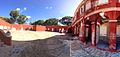
Inner courtyard (south)
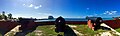
Old cannons


See also
Web links
Commons : Fort Frederik - collection of pictures, videos and audio files
Individual evidence
- ↑ Archive link ( Memento of the original from May 22, 2008 in the Internet Archive ) Info: The archive link was inserted automatically and has not yet been checked. Please check the original and archive link according to the instructions and then remove this notice.
- ↑ http://focus.nps.gov/pdfhost/docs/NHLS/Text/97001269.pdf
- ↑ http://focus.nps.gov/AssetDetail/NRIS/76001853
- ↑ The fortress is therefore a US Historic District Contributing property .
- ↑ https://www.nps.gov/nr/travel/prvi/pr49.htm