Foxe Peninsula
| Foxe Peninsula | ||
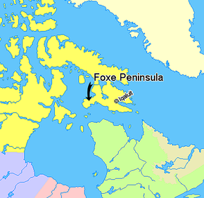
 The Foxe Peninsula on a map of the Canadian Northeast |
||
| Geographical location | ||
|
|
||
| Coordinates | 64 ° 43 ′ N , 77 ° 30 ′ W | |
| Waters 1 | Foxe Basin , Foxe Channel | |
| Waters 2 | Hudson Street | |
| length | 241 km | |
| width | 161 km | |
The Foxe Peninsula , named after the explorer Luke Foxe , is an uninhabited peninsula in the south of Baffin Island in Canada , with which the peninsula is only connected by a narrow land bridge. The Foxe Peninsula administratively belongs to the Qikiqtaaluk region in Nunavut . The closest settlement is Cape Dorset on the barrier island of Dorset Island in the south.
North of the peninsula is the Foxe Basin , west of the Foxe Canal and south of the Hudson Strait begins . Also south of the peninsula is a small island on which the settlement Cape Dorset is located. The westernmost point of the peninsula is called Cape Queen .
The peninsula is 241 kilometers long and 80 to 161 kilometers wide.
