Freihamer Allee
| Freihamer Allee | |
|---|---|
| Street in Munich | |
| Freihamer Allee after Gut Freiham in the direction of Graefelfing | |
| Basic data | |
| State capital | Munich |
| Borough | Aubing-Lochhausen-Langwied |
| Created | probably 17th century |
| Connecting roads | in Graefelfing: Freihamer Straße |
| Cross streets | Bodenseestrasse, Centa-Hafenbrädl-Strasse |
| Places | Mudflats |
| Numbering system | Orientation numbering |
| Buildings | Railway line Munich – Herrsching , Church of the Holy Cross (Freiham) , Freiham Castle , |
| use | |
| User groups | Pedestrian traffic , bicycle traffic , individual traffic (partially) |
| Technical specifications | |
| Street length | 1.7 km |
The Freihamer avenue is a avenue in the Munich district Aubing in the area of Guts Freiham that was probably built in the 17th century.
course
Freihamer Allee starts from Bodenseestraße ( Bundesstraße 2 ) and crosses under the Munich – Herrsching railway line before it passes through Gut Freiham. Directly south of the railway line, the Wattplatz branches off to the west. South of Gut Freiham, Centa-Hafenbrädl-Strasse, which connects to the Freiham development area, joins the avenue from the east. Then Freihamer Allee runs south and is designed as an avenue. It continues in the direction of Graefelfing and is interrupted by the Bundesautobahn 96 ( Munich - Lindau ), which it crosses with a pedestrian bridge, slightly to the east. At the city limits of Graefelfing in the Graefelfinger Holzwiesen it turns into Freihamer Straße there.
By 2013 it crossed the Munich – Herrsching railway line via a level crossing that was controlled from the Munich-Freiham train station . The level crossing was closed in September 2013 and replaced by a pedestrian and cycle path underpass in 2015.
Buildings
See also: Gut Freiham , section individual buildings
- Freihamer Allee (without number): former cowshed I of the Freiham estate (19th century)
- Freihamer Allee 21/23: Schlosswirtschaft Freiham
- Freihamer Allee 22: former horse stable (18th century)
- Freihamer Allee 24: Catholic Church Heilig Kreuz (built from the 15th century) within a cemetery (17th to 20th century)
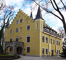
- Freihamer Allee 31: Freiham Castle with park, 17th century core, changed in a neo-Gothic style in 1865
Web links
literature
- Dennis A. Chevalley, Timm Weski: City of Munich . Southwest. In: Bavarian State Office for Monument Preservation (Hrsg.): Monuments in Bavaria - independent cities and districts . Volume I.2 / 2, 2 half volumes. Karl M. Lipp Verlag, Munich 2004, ISBN 3-87490-584-5 .
Individual evidence
Coordinates: 48 ° 8 ′ 10.2 " N , 11 ° 24 ′ 11.8" E

