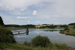
Weilerbach dam
| Weilerbach dam | |||||||||
|---|---|---|---|---|---|---|---|---|---|
| View from the dam of Freilinger See | |||||||||
|
|||||||||
|
|
|||||||||
| Coordinates | 50 ° 25 '12 " N , 6 ° 43' 12" E | ||||||||
| Data on the structure | |||||||||
| Construction time: | -1976 | ||||||||
| Height above valley floor: | 25 m | ||||||||
| Height above foundation level : | 28 m | ||||||||
| Building volume: | 300 000 m³ | ||||||||
| Crown length: | 380 m | ||||||||
| Crown width: | 13.5 m | ||||||||
| Data on the reservoir | |||||||||
| Water surface | 9 ha | ||||||||
| Storage space | 0.73 million m³ | ||||||||
| Catchment area | 4.82 km² | ||||||||
The Weilerbach dam , better known in the region as Freilinger See , is located near Freilingen , about 10 km southeast of Blankenheim in the northern Eifel .
The dammed body of water is the hamlet in the Ahr river basin . The barrier structure of the lake was designed as a stone embankment with a bituminous outer skin seal. District road 41 leads over the dam. The operator of the dam is the municipality of Blankenheim.
The lake was primarily built to protect the people below from flood damage, and the numerous visitors like to accept it as a well-frequented local recreation area. About a third of its bank consists of lawn and two thirds of forest. The water is relatively cold, but very clean. You can swim, go boating, windsurfing, diving and fishing, among other things. There is a camping and mini golf course and a restaurant by the lake. Around the lake there is an approx. 2.1 km long hiking trail with an educational forest trail, which brings visitors closer to the native deciduous and coniferous species.
The lake is the destination of the first stage of the AhrSteig long-distance hiking trail from Blankenheim , the end point is Sinzig .
In the geological underground of Lake Freilingen weak foliated sound and siltstone are the Klerfer layers (the upper Unterems , Devonian ).
Individual evidence
- ↑ Information board at the lake of the Blankenheim municipal administration
Web links
- Dams directory NRW (PDF; 122 kB)
- Dams in North Rhine-Westphalia; State Environment Agency NRW (PDF; 124 kB)
- The Freilinger See, with pictures
- with map
- Recordings from the lake
literature
See also:


