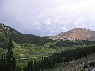
Fremont Pass
| Fremont Pass | |||
|---|---|---|---|
|
seen from the southwest, behind the molybdenum open-cast mine |
|||
| Compass direction | North | south | |
| Pass height | 3450 m | ||
| county | Summit County , Colorado ( USA ) | Lake County , Colorado ( USA ) | |
| Watershed | Blue River → Colorado River | Headwaters of the Arkansas River → Mississippi | |
| Valley locations | Frisco | Leadville | |
| expansion |
|
||
| Mountains | Rocky mountains | ||
| map | |||
|
|
|||
| Coordinates | 39 ° 21 '59 " N , 106 ° 11' 12" W | ||
The Fremont Pass is a mountain pass in the Rocky Mountains . It is located in the west of the US state Colorado on the border of the counties Summit County and Lake County . The pass was named after its discoverer John Charles Fremont , who found the pass in the 1840s.
The continental watershed runs over the pass .
Just northeast of the pass there is a large molybdenum - open pit . The mine has been shut down since 1995 because mining the ore is not profitable at current world market prices.

Relief map of the passport and the molybdenum mine . The pass is on the red road at the bottom of the map.

