Frentrop
|
Frentrop
City of Marl
Coordinates: 51 ° 39 ′ 0 ″ N , 7 ° 3 ′ 46 ″ E
|
|
|---|---|
| Height : | approx. 60 m |
| Area : | 4.33 km² |
| Residents : | 416 (December 31, 2015) |
| Population density : | 96 inhabitants / km² |
|
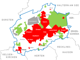
Location within the city of Marl
|
|
Frentrop is an older settlement and today the namesake of a statistical district in the Alt-Marl district of the city of Marl .
location
Frentrop is west of the center of Alt-Marl, the Polsum district is 2.5 kilometers south-southwest. The center of Marl is a good two kilometers east-northeast, the inner city of Recklinghausen is ten kilometers southeast.
history
The place goes back to a farming community in Vest Recklinghausen . The name is of Old Saxon origin and means place of a free one . This meant former soldiers and peasants in the Franconian Empire who did not have to do any compulsory or tension service and no tithe . Documents speak of Vrilinctorpe , the name of the later farmers Frentrop, which can be traced back to the settlement of Saxon Frilinge in the seventh century . In 1927, an urn cemetery from the Neolithic Age was opened in Frentrop .
In terms of pastoral care, Frentrop belongs to St. Georg in Marl and the corresponding Protestant parish.
economy
The Marl-Frentrop Technology Park borders northwest of the old Frentrop . The commercial area is part of the Dorsten / Marl industrial park and borders directly on the neighboring town of Dorsten to the west .
societies
The Schützenbruderschaft celebrates a shooting festival every two years.

