Friedensbrücke (Bautzen)
The Peace Bridge ( Upper Sorbian Most Mera ) in Bautzen is one of the larger stone arch bridges in Saxony and next to the motorway bridge of the A4 and the bridge of the west bypass one of the three most important are the Spree crossing links for road traffic of the city. The four basket arches, which are placed on massive pillars and abutments, span the deeply cut and steep-walled Spree Valley at a height of over 20 meters over a length of 181 meters.
history
The historical city access via the Heilige-Geist-Brücke and the Hammermühlenbrücke required the downward and upward movement through the Spreetal, which turned out to be an unsatisfactory solution , especially in the age of increasing traffic in connection with industrialization .
After two years of construction, the bridge was named Kronprinzenbrücke in 1909 by the Saxon King Friedrich August III. inaugurated. The design was created by the Royal Road and Water Construction Inspectorate since 1903, with the major involvement of the building officer Artur Speck , who later also largely coordinated the implementation of the project. In addition to the considerable easing of traffic, the construction of the Friedensbrücke only now made it possible to develop more significant settlement areas west of the Spree. For centuries, the natural barrier of the river forced the city to expand further and further to the east, so that the historic city center shifted further and further to the geographical edge of the settlement. Such a tendency can still be seen after the bridge was built up to the present day, but the Westvorstadt , which is often referred to as Bautzen-Neustadt , came into being after 1909 .
In connection with the Battle of Bautzen in World War II , the bridge and 16 other bridges were blown up on the evening of April 20, 1945, and large parts of it were destroyed in the process. Despite considerable financial difficulties and multiple interruptions to construction due to a lack of material, the bridge was opened to traffic again in 1949. It was now named Friedensbrücke as a reminder of the destruction of the city during the war. After the fall of the Wall , another overhaul of the bridge became necessary, most of which was realized in 1998. The renovation in cooperation with the State Office for the Preservation of Monuments in Saxony has been rated several times as a successful example of how to deal with historical buildings.
After 104 years in which long-distance traffic in the course of Bundesstrasse 6 and Bundesstrasse 96 (formerly R 6/96 and F 6/96) used the bridge and caused long traffic jams on the bridge at rush hours, this function was taken over by the Opening of the inner city bypass west bypass revoked in December 2013.
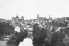
City view of Bautzen from the Friedensbrücke
When building the bridge, for design reasons, the variant of a massive stone bridge was preferred to a light, elegant construction, although there were stipulations and requirements for a minimum amount of building materials. The massiveness should do justice to the defiant cityscape of Bautzen. Nevertheless, there were also critical voices, as the usual picturesque townscape on the banks of the Spree has been greatly changed in some familiar visual relationships or blocked by the bridge. However, the bridge itself gave new insights into the city of Bautzen. The view from the Friedensbrücke is the most famous motif in the city today and is also one of the most frequently used photo motifs in all of Saxony and can be found regularly on the covers of books or on calendars on the topic of Saxony.
Individual evidence
- ↑ Bautzener Tageblatt of May 2, 1945, report on the fighting for Bautzen
literature
- Hagen Schulz: Milestone in Saxon traffic history - 100 years of the Friedensbrücke in Bautzen , Lusatia Verlag Bautzen 2009
Web links
- 9th Bridge Construction Symposium 1999, p. 16 ( Memento from September 9, 2003 in the Internet Archive ) (PDF file, 71.8 kB)
Coordinates: 51 ° 10 '46.4 " N , 14 ° 25' 14.9" E


