Fujinuma Dam
| Fujinuma Dam | |||||
|---|---|---|---|---|---|
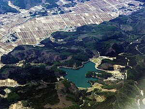
| Fujinuma Reservoir 2009, bottom center: dam | |||||
|
|||||
|
|
|||||
| Coordinates | 37 ° 18 '7 " N , 140 ° 11' 41" E | ||||
| Data on the structure | |||||
| Lock type: | dam | ||||
| Construction time: | 1949 | ||||
| Height of the barrier structure : | 17.5 m | ||||
| Building volume: | 99 000 m³ | ||||
| Crown length: | 133 m | ||||
| Operator: | Ebana Riverside Land Development Project | ||||
| Data on the reservoir | |||||
| Water surface | 20 ha | ||||
| Storage space | 1.504 million m³ | ||||
| Catchment area | 8.8 km² | ||||
| Particularities: |
broke on March 11, 2011 |
||||
The Fujinuma Dam ( Japanese 藤 沼 ダ ム , Fujinuma-damu ) was a dam in Sukagawa , Fukushima Prefecture , Japan , which was completed in 1949 . He stood at the Ebana-gawa ( 江 花 川 ), a tributary of the Abukuma 16 km west of the Sukagawa town hall. The main purpose of the dam was irrigation . The dam broke on March 11, 2011 as a result of the Tōhoku earthquake .
The reservoir was known as the Fujinuma Reservoir ( 藤 沼 貯 水池 , Fujinuma-chosuichi ) or Fujinuma Lake ( 藤 沼 湖 , Fujinuma-ko ).
Building
The dam was a 17.5 m high and 133 m long embankment dam with a structure volume of 99,000 m³. The dam stood at the end of an 8.8 km² catchment area and the reservoir had a capacity of 1,504,000 m³ with the same usable space. The reservoir had a water surface of 20 hectares. The dam was built by Shōji Kensetsu KK and was operated by the land development project Ebana River Bank ( 江 花 川 沿岸 土地 改良 区 , Ebana-gawa engan tochikairyōku ).
Dam break
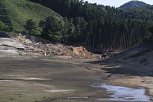
On March 11, 2011, the dam broke as a result of the Tohoku earthquake. Local residents reported hearing a loud noise before they saw a tidal wave . The flood washed away five houses and damaged others, damaged a bridge and blocked roads with debris. Eight people were missing and four bodies were found after a search that began after dawn.
On March 12, 252 dams were inspected and seven of them were found damaged. Six embankments had shallow cracks at the top of the dams and the reservoir of a concrete gravity dam showed a slight break in the slope . Four dams including Fujinuma were inaccessible and could not be inspected. As soon as the streets were cleared, further inspections should take place.
See also
Individual evidence
- ↑ a b c 藤 沼 ダ ム [福島 県] (ふ じ ぬ ま) . In: ダ ム 便 覧 (“dam manual”). 財 団 法人 日本 ダ ム 協会 (“legal foundation Japanese dam association”), accessed on May 29, 2011 (Japanese).
- ↑ Maps of the national land surveying office: http://watchizu.gsi.go.jp/watchizu.aspx?b=371801&l=1401135
- ↑ ダ ム 決 壊 で 8 人 不明 家 屋 流 さ れ る 福島 ・ 須 賀 川 市 . (No longer available online.) In: MSN 産 経 ニ ュ ー ス . MSN / Sankei Shimbun , March 12, 2011, archived from the original April 18, 2011 ; Retrieved May 29, 2011 (Japanese). Info: The archive link was inserted automatically and has not yet been checked. Please check the original and archive link according to the instructions and then remove this notice.
- ↑ 片 桐 大 介 : ダ ム 決 壊 5 棟 流出 福島 ・ 須 賀 川 . (No longer available online.) Kahoku Shimpō, March 13, 2011, archived from the original on August 19, 2011 ; Retrieved May 29, 2011 (Japanese, newspaper archive subject to registration). Info: The archive link was inserted automatically and has not yet been checked. Please check the original and archive link according to the instructions and then remove this notice.
- ^ Dam Breaks In Northeast Japan, Washes Away Homes. In: Arab Times. March 12, 2011, accessed May 29, 2011 .
- ^ A quick report on Japanese Dams after the Earthquake. Chinese National Committee on Large Dams, March 14, 2011, accessed May 29, 2011 .
Web links
- Fujinuma Dam. In: Structurae
- Dam breaks following Japan earthquake, homes washed away
- Failure of Fujinuma Dam during the 2011 Tohoku Earthquake. scientific treatise on the dam breach (PDF file; 414 kB)
- Geotechnical Reconnaissance of the 2011 Tohoku Japan Earthquake
- Analysis of the Fujinuma Dam Failure. Youtube video
- Fujinuma Reservoir, Fukushima Pref., Japan. Youtube video


