
Fullarton Water
| Fullarton Water | ||
 Fullarton Water |
||
| Data | ||
| location | Midlothian , Scotland | |
| River system | Esk | |
| Drain over | Redside Burn → South Esk → Esk → Firth of Forth → North Sea | |
| source | Confluence of two streams 55 ° 47 ′ 5 ″ N , 3 ° 9 ′ 8 ″ W |
|
| muzzle | In the Edgelaw Reservoir coordinates: 55 ° 48 ′ 41 ″ N , 3 ° 7 ′ 36 ″ W 55 ° 48 ′ 41 ″ N , 3 ° 7 ′ 36 ″ W.
|
|
| length | 5 km | |
The Fullarton Water is a stream in the south of the Scottish Council Area Midlothian .
course
The creek is created by the confluence of Loch Burn and Tweeddale Burn northwest of Gladhouse Reservoir off the northern flank of the Moorfoot Hills . While the Tweeddale Burn rises on the slopes of Hog Hill , Loch Burn is the outflow from the Portmore Reservoir , which is located off the flank of the Dundreich .
The Fullarton Water flows mainly in a northeast direction. After about five kilometers, it pours into the Edgelaw Reservoir on its southwest side . The outflow from the reservoir is called the Redside Burn .
Surroundings
The Fullarton Water flows through a sparsely populated region in southern Midlothian. There is no significant settlement along its course. The B6372 crosses Fullarton Water on its way from Penicuik to Pathhead . As part of the waterway between Portmore Reservoir and Edgelaw Reservoir, the Fullarton Water is used to supply drinking water.
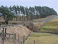
Crossing the B6372

Mouth into the Edgelaw Reservoir


Individual evidence
- ↑ a b c Entry in the Gazetteer for Scotland
- ↑ a b c Map of the Ordnance Survey