Funkenburg (Lausitzer Bergland)
| Funkenburg | ||
|---|---|---|
|
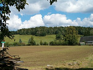
View of the Funkenburg near Wehrsdorf |
||
| height | 376 m | |
| location | Free State of Saxony , Germany | |
| Mountains | Lusatian highlands | |
| Coordinates | 51 ° 3 '46 " N , 14 ° 24' 2" E | |
|
|
||
| rock | Granodiorite | |
The Funkenburg , also Funkenberg , is an elevation in the Lausitzer Bergland in Saxony in the Bautzen district . It is about 50 meters above the surrounding landscape and at the highest point 376 meters above sea level.
About 1 km northeast of Wehrsdorf (district of the municipality of Sohland an der Spree ) it pushes itself like a bastion from the north between the Kaltbach and the forest water into the Wehrsdorf valley and belongs to the Lusatian highlands , whose numerous higher elevations rise an average of 500 meters above sea level. It is an offshoot of the ridge between the Hohberg and the Steinberg and is interspersed with lamprophyr tunnels. A water-filled quarry and rubble heaps are still reminiscent of the quarry mining, which was in progress until around 1915.
Correctly it should be called Funkenberg. Around the middle of the 19th century the house on the heights burned down. A new small tavern at the quarry was then popularly called "Funkenburg", but in 1897 it burned down again. The current simple hut dates from 1929, which was fully managed as an excursion restaurant until the 1960s. After many changes of ownership, the Funkenburg came back into firm hands in 1997. This stopped the decline of the historic mining building from 1929. Since then, numerous hours of work have taken care of maintaining the Funkenburg in its original form and (wood) construction. Once a year, always on Ascension Day, there is a “Funkenburg Open Day”.
From a ledge you have a good view over the Wehrsdorf valley and the Sohlander heights. Behind it you can see the Czech basalt mountains Špičák (Spitzberg, 481 m) near Císařský (Kaiserswalde), Partyzánský vrch (Botzen, quarry) and Hrazený (Pirsken, 610 m), both near Šluknov (Schluckenau).
literature
- Around Bautzen and Schirgiswalde (= values of the German homeland . Volume 12). 1st edition. Akademie Verlag, Berlin 1967, p. 204.

