Furth (Oberhaching)
|
Furth
community Oberhaching
Coordinates: 48 ° 1 ′ 46 " N , 11 ° 35 ′ 58" E
|
||
|---|---|---|
| Postal code : | 82041 | |
| Area code : | 089 | |
|
Location of Furth in Oberhaching |
||
|
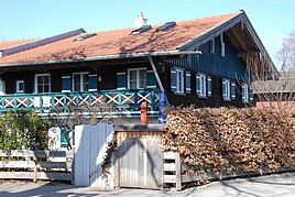
Farm in Furth
|
||
Furth is a part of the municipality of Oberhaching in the district of Munich . It is located at a crossing point over the Hachinger Bach and is first mentioned in written sources in 1172.
The municipality of Furth borders in the north on the Perlacher Forst , in the south on the municipality Deisenhofen (Oberhaching) , in the west on the municipality Grünwald and in the east on the municipality Taufkirchen .
Furth is known for the Kugler Alm restaurant and beer garden . Cyclists can easily cross the Furth area, as an asphalt, car-free route leads from Säbener Platz in Munich through the Perlacher Forest to Furth. People like to take a break in the beer garden of the Kugler Alm or extend the bike tour further into the Oberland.
In terms of transport, Furth is linked to the A 995 motorway by the Munich – Holzkirchen railway line and the Oberhaching Grünwald bypass (M11) and the Oberhaching junction . There is also a train - stop in Furth (S3).
The Oberhaching sports school and the Furth natural swimming pool are also known in the region.
Furth also has the industrial area of the municipality of Oberhaching.

