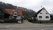
Gütighofen
The hamlet of Gütighofen in the Breisgau-Hochschwarzwald district belongs to both Ehrenkirchen and Bollschweil . The border between the two communities runs exactly on the only street that is also called "Gütighofen".
location
The place is at the southern entrance of the Hexental , at the confluence of the Eckbach and Möhlin , directly below the Ölberg (417 m), the southernmost elevation of the Schönberg . This includes both Hauenfels Castle and the “ Devil's Kitchen ”, a complex of reindeer hunters from the Paleolithic . There is also the Teufelskanzel , a stand-alone rock made of roe stones from the Middle Jurassic , which hikers use as a vantage point. The eastern side of the valley belongs to the Black Forest .
Gütighofen is located on the Bettlerpfad hiking trail .
history
The first written mention of Gütighofen as Gnittinhovin could come from the year 1270. Documented for the year 1344 is the mention of Güttikoven , which referred to a personal name.
The oldest building in the district is the rock mill . The farms were probably grouped around it later. At the end of 1852, three families with a total of 15 people lived in the Bollschweiler part of the hamlet, while the Ehrenstetter part consisted of eight families with 36 people. In the meantime, there is no longer any commercial agriculture; the only local company is the joinery and carpentry Steiert und Armbruster .
Individual evidence
- ↑ a b Harry Herold: A snail faunula of the rock falls on the eastern flank of the Mount of Olives near Ehrenstetten in Breisgau (PDF; 1.8 MB). in: Communications of the Zoological Society Braunau 1/1970 , ISSN 0250-3603 , pp. 177-185
- ↑ Karlheinz Scherfling: Gastronomy: Pleasure hiking in southern Baden: St. Gotthardthof: Hiking on the beggar's path , Badische Zeitung, June 12, 2010, accessed on May 14, 2013
- ↑ a b Gütighofen (Wohnplatz) , leo-bw.de, accessed on May 14, 2013
- ^ Ministry of the Interior (ed.): Contributions to the statistics of the internal administration of the Grand Duchy of Baden , Müller, Karlsruhe 1855, p. 108, full text in the Google book search
Coordinates: 47 ° 55 ' N , 7 ° 46' E

