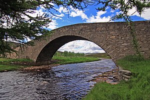
Gairnshiel Bridge
Coordinates: 57 ° 5 '36 " N , 3 ° 9' 55" W.
| Gairnshiel Bridge | ||
|---|---|---|
| Gairnshiel Bridge | ||
| use | Road bridge | |
| Convicted | A939 | |
| Subjugated | Gairn | |
| place | northeast of Crathie | |
| construction | Stone arch bridge | |
| Number of openings | 1 | |
| Clear width | 17.3 m | |
| completion | 1749 | |
| location | ||
|
|
||
The Gairnshiel Bridge is a road bridge near the Scottish village of Crathie in the Council Area of Aberdeenshire . In 1971 the bridge was included in the Scottish monument lists, initially in category B. The upgrade to the highest monument category A took place in 1994.
history
In order to reduce the reaction times of the Scottish military, General Wade pushed ahead with the expansion of the Scottish military road network as a result of the Jacobite Uprising in 1745 . The Gairnshiel Bridge was built as part of the military road between Blairgowrie and Fort George around 1749 by Wade's successor William Caulfeild . Today it bears the of Nairn by Bridge of Gairn leading A939 .
description
The Gairnschiel Bridge is located in a sparsely populated region of Aberdeenshire about six kilometers northeast of Crathie and northwest of Bridge of Gairn. The masonry viaduct spans the Gairn with a segmental arch with a clear width of 17.3 m. A parapet delimits the steep road on the quarry stone bridge. It is around one meter high at the highest point and flattens out to around 20 cm on both sides.
Individual evidence
- ↑ a b c Listed Building - Entry . In: Historic Scotland .
- ↑ a b Entry on Gairnshiel Bridge in Canmore, the database of Historic Environment Scotland (English)
Web links
- Entry on Gairnshiel Bridge in Canmore, Historic Environment Scotland database

