
Blairgowrie and Rattray
|
Blairgowrie and Rattray Scottish Gaelic Blàr Ghobharaidh, Raitear |
|||
|---|---|---|---|
 |
|||
| Coordinates | 56 ° 36 ′ N , 3 ° 20 ′ W | ||
|
|||
| Residents | 8954 2011 census | ||
| administration | |||
| Post town | BLAIRGOWRIE | ||
| ZIP code section | PH10 | ||
| prefix | 01250 | ||
| Part of the country | Scotland | ||
| Council area | Perth and Kinross | ||
| British Parliament | Perth and North Perthshire | ||
| Scottish Parliament | Perthshire North | ||

Blairgowrie and Rattray ( Gaelic : Blàr Ghobharaidh and Raitear ), colloquially known as Blair for short , is an amalgamation of two small Scottish towns in the Unitary Authority Perth and Kinross . It is about 19 km north-northeast of Perth and about 25 km northwest of Dundee . In 2011 Blairgowrie and Rattray had 8954 inhabitants. Blairgowrie means something like "wild goat plain".
history
Blairgowrie and Rattray grew as individual settlements separated by the River Ericht , with Blairgowrie on the west bank and Rattray on the east bank. Both villages were connected by a bridge early on. With the introduction of water-powered textile mills, the villages grew. The fertile soils of the area are now used for fruit growing. In the course of industrialization in the 19th century Blairgowrie grew rapidly from 1025 inhabitants in 1811 to 3950 in 1881. Between 1961 and 1991, a second growth phase can be identified, in which another 2800 people were added. The population of Rattray doubled between 1831 and 1881 to 2533.
The Parkneuk Stone Circle is on the Cateran Trail, about 4 miles north of Blairgowrie. The Ardblair stone circle cut by Essendy Road (B947) is southwest of Blairgowrie.
traffic
Blairgowrie and Rattray is linked to the trunk road network by the A93 , which connects Perth to Aberdeen via Ballater . Coming from the south, the road crosses Blairgowrie, crosses the Ericht and finally leaves Rattray towards the northwest. The bridge between the two parts of the city already existed in the 19th century and was modernized and widened in 1871. In 1855 Blairgowrie was connected to the railway network. For this purpose, a branch line was led from Coupar Angus to Blairgowrie, which ended there. However, the line is no longer in operation today.

Rattray as seen from Cowdenbeath

The ericht between both parts of the city
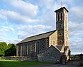
Church in Rattray

The Ardblair stone circle, divided by a road


Web links
Individual evidence
- ^ List of Gaelic expressions
- ^ List of Gaelic expressions
- ↑ a b Entry in the Gazetteer for Scotland
- ↑ 2011 census
- ↑ a b Blairgowrie. In: Francis H. Groome: Ordnance Gazetteer of Scotland: A Survey of Scottish Topography, Statistical, Biographical and Historical. Volume 1: (A - Coru). Thomas C. Jack, Grange Publishing Works, Edinburgh et al. 1882, pp. 166-167.
- ^ Robert McDonald: Parish of Blairgowrie. In: The New Statistical Account of Scotland. Volume 10: Perth. William Blackwood and Sons, Edinburgh et al. 1845, pp. 897-933 .
- ↑ entry. In: Gazetteer for Scotland. 2011.
- ↑ entry. In: Gazetteer for Scotland. 2011.