
Ericht (Isla)
| Ericht | ||
 |
||
| Data | ||
| location | Perth and Kinross , Scotland | |
| River system | Tay | |
| Drain over | Isla → Tay → Firth of Tay → North Sea | |
| source | Confluence of the Ardle and Black Water about 0.5 km east of Bridge of Cally 56 ° 38 ′ 52 ″ N , 3 ° 23 ′ 26 ″ W |
|
| Source height | about 150 m ASL | |
| muzzle | about three kilometers northeast of Coupar Angus in the Isla coordinates: 56 ° 34 ′ 18 " N , 3 ° 14 ′ 29" W 56 ° 34 ′ 18 " N , 3 ° 14 ′ 29" W |
|
| Mouth height | about 35 m ASL | |
| Height difference | about 115 m | |
| Bottom slope | about 7.2 ‰ | |
| length | 16 km | |
The Ericht is a river in the Scottish council area of Perth and Kinross . It is created by the confluence of the Ardle and Black Water creeks a few hundred meters east of Bridge of Cally in the Grampian Mountains at a height of about 150 m. The Ericht is not to be confused with the second river Ericht , which also runs through Perth and Kinross and flows into the Tay via Loch Rannoch and the Tummel .
Run
The Ericht initially flows in a south-southeast direction along the A93 , which crosses it shortly before and a second time in Blairgowrie and Rattray . Beyond Blairgowrie and Rattray, the Ericht turns in an east-southeast direction and joins the Isla a few kilometers further downstream about three kilometers east of Coupar Angus .
Over its entire course of ten kilometers, the Ericht overcomes a height difference of around 115 m. The bed of the fast flowing river is rocky. In the 19th century, salmon and trout lived in the Ericht, but their stocks were decimated by industrial plants in Blairgowrie and Rattray.

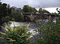
The Ericht in Blairgowrie
Bridge over the Ericht
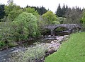
The Ardle, one of the two source rivers of the Ericht


Web links
Individual evidence
- ↑ a b c d e Ericht, River. In: Francis H. Groome: Ordnance Gazetteer of Scotland: A Survey of Scottish Topography, Statistical, Biographical and Historical. Volume 3: (Edr - Har). Thomas C. Jack, Grange Publishing Works, Edinburgh et al. 1885, p. 574.
- ↑ Ericht, River. In: David Munro, Bruce Gittings: Scotland. An Encyclopedia of Places & Landscapes. Collins et al., Glasgow 2006, ISBN 0-00-472466-6 .