Tay
|
Tay Abhainn Tatha |
||
|
The Tay in Perth |
||
| Data | ||
| location | Scotland | |
| River system | Tay | |
| source | On the slopes of Ben Lui 70 km northwest of Glasgow 56 ° 24 ′ 8 ″ N , 4 ° 47 ′ 50 ″ W |
|
| Source height | 610 m | |
| muzzle | At Perth in the Firth of Tay, this east of Dundee in the North Sea coordinates: 56 ° 27 '33 " N , 2 ° 47' 22" W 56 ° 27 '33 " N , 2 ° 47' 22" W |
|
| Mouth height | 0 m | |
| Height difference | 610 m | |
| Bottom slope | 3.2 ‰ | |
| length | 193 km | |
| Catchment area | 6216 km² | |
| Drain |
MQ |
170 m³ / s |
| Flowing lakes | Loch Tay | |
The Tay [ teɪ ] ( Scottish Gaelic Tatha or Abhainn Tatha ) is the longest river in Scotland at 193 km . It rises on the slopes of Ben Lui and flows first into the Firth of Tay and finally into the North Sea .
Inland waters
In the upper reaches he is called Fillan until he becomes Dochart at Crianlarich . At Killin it forms the spectacular waterfalls of the Dochart Falls , only to pour a few hundred meters further from the southwest into the lake Loch Tay . After it has left this at the northeast end at Kenmore , it flows as the River Tay first in a northeastern direction past the grounds of the Taymouth Castle , then in a southerly direction through Aberfeldy , Dunkeld and Perth .
Firth of Tay
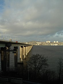
Four kilometers east of Perth, the River Tay flows into the Firth of Tay , into which the Earn River also flows south of the River Tay . East of Dundee , the Firth of Tay opens to the North Sea at Broughty Ferry .
This Firth of Tay is included in the river length. The flow rate is given separately for the River Tay (in Perth) and River Earn. The salinity of the Firth of Tay indicates a significant influx of seawater. This makes this estuary more than just an ordinary underflow. Although it was formed as a fjord by ice age glaciers, it is not very deep these days. Between the river mouths and Dundee, more than half the width of the Firth of Tay is occupied by tidal flats.
Hydrology
The Tay has the largest catchment area of all Scottish rivers with 6216 km² . On average, it transports 170 m³ of water per second. The highest measured water volume was 2269 m³ / s on January 17, 1993, when the level in Perth rose 6.48 m above normal, which led to extensive flooding in the city. The highest water level in Perth occurred in 1814 with 7 m above normal. Further floods were recorded in 1210 and 1648.
history
During the Romantic era at the beginning of the 19th century, enthusiastic landowners built ruins on the hilltops. The banks of the Firth of Tay with its mountainsides rising close to the water reminded them of the landscape on the Middle Rhine with its castle ruins. Such senseless and pointless buildings, which only come from the whim of their creators, are called follies in English .
A momentous disaster was the collapse of the newly built railway bridge over the Firth of Tay near Dundee on December 28, 1879, in which 75 people lost their lives. Several poems were written about this event, including Die Brück 'am Tay by Theodor Fontane .
Place names
Several places along the river have been named after the Tay:
- Dundee = Dun Deagh, Fort on the Tay
- Broughty Ferry, also called Brochtie by the residents = Bruach Tatha, bank of the Tay
- Taymouth Castle - Castle near the Tay.
In Antarctica, the Firth of Tay Sound is named after the river.
literature
- Tay . In: Meyers Konversations-Lexikon . 4th edition. Volume 15, Verlag des Bibliographisches Institut, Leipzig / Vienna 1885–1892, p. 552.


