
Ardle (river)
| Ardle | ||
 |
||
| Data | ||
| location | Perth and Kinross , Scotland | |
| River system | Tay | |
| Drain over | Ericht → Isla → Tay → Firth of Tay → North Sea | |
| source | The confluence of the Allt Fearnach and Brerachan Water rivers about 14 km northeast of Pitlochry 56 ° 48 ′ 46 ″ N , 3 ° 35 ′ 41 ″ W |
|
| muzzle | 0.5 kilometers east of Bridge of Cally in the Ericht Coordinates: 56 ° 38 ′ 52 " N , 3 ° 23 ′ 26" W, 56 ° 38 ′ 52 " N , 3 ° 23 ′ 26" W |
|
| Mouth height | about 150 m ASL
|
|
| length | 21 km | |
The Ardle , also obsolete Airdle , is a river in the Scottish council area of Perth and Kinross . It is formed by the confluence of the Allt Fearnach and Brerachan Water creeks about 14 km northeast of Pitlochry
The Ardle flows in a south-easterly direction through a sparsely populated, mountainous region. From about five kilometers after its formation, the Ardle runs along the A924 to its mouth at Bridge of Cally , which connects the A93 at Bridge of Cally with the A9 at Pitlochry. The Ardle flows into the Ericht after a total of 21 km and thus finally reaches the North Sea via Isla and Tay .

The Ardle in Bridge of Cally just before its mouth
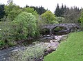
Bridge over the Ardle


Web links
Commons : Ardle - collection of images, videos and audio files
Individual evidence
- ↑ Ericht, River. In: Francis H. Groome: Ordnance Gazetteer of Scotland: A Survey of Scottish Topography, Statistical, Biographical and Historical. Volume 3: (Edr - Eyn). Thomas C. Jack, Grange Publishing Works, Edinburgh et al. 1883, pp. 574-575.
- ↑ a b c Airdle. In: Francis H. Groome: Ordnance Gazetteer of Scotland: A Survey of Scottish Topography, Statistical, Biographical and Historical. Volume 1: (A - Coru). Thomas C. Jack, Grange Publishing Works, Edinburgh et al. 1882, p. 36.
- ↑ a b Ardle, River. In: David Munro, Bruce Gittings: Scotland. An Encyclopedia of Places & Landscapes. Collins et al., Glasgow 2006, ISBN 0-00-472466-6 .