Gangdisê
| Gangdisê | ||
|---|---|---|
|
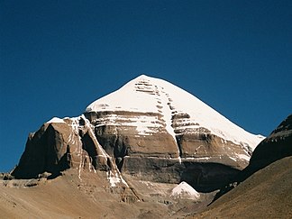
The holy Mount Kailash in the Gangdisê Mountains |
||
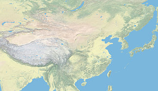
| location | Tibet ( PR China ) | |
| part of | Transhimalaya | |
|
|
||
| Coordinates | 31 ° N , 83 ° E | |
| Tibetan name |
|---|
|
Tibetan script :
གངས་ ཏི་ སེ
|
|
Wylie transliteration : gangs ti se
|
|
Official transcription of the PRCh : Gangdisê
|
|
THDL transcription : Gangtise
|
|
Other spellings: -
|
| Chinese name |
|
Traditional :
岡底斯 山
|
|
Simplified :
冈底斯 山
|
|
Pinyin : Gāngdǐsī Shān
|
The Gangdisê is a 1000 kilometer long mountain range in Tibet . Together with the Nyainqêntanglha mountain range to the east, it forms the Transhimalaya mountain system.
Location and landscape
The Gangdise group partially forms the divide between the after India dewatered streams Indus , Sutlej , Karnali and Yarlung Zangbo ( Brahmaputra -Oberlauf) and the Nu Jiang (Salween) and forms the western part of since Hedin the west Transhimalaya said mountain ranges. These rivers all have their source in the west of these mountains. To the north, the Gangdisê runs out into the vast alpine steppes of the Changthang .
summit
The most important, if not the highest, peak is the 6,714 m high sacred mountain Gang Rinpoche , which is called Kailash in India and in the west . That is why the Tibetan term "Gangdisê" is often used both on the holy mountain and the entire mountain range.
Individual evidence
- ↑ 《中国 地 名录》. Beijing, 中国 地图 出版社 1997, ISBN 7-5031-1718-4 , p. 68.

