Cooker
| Garkalne sds | ||
|---|---|---|
 Help on coat of arms |
|
|
| Basic data | ||
| State : |
|
|
| Landscape: | Livonia ( Latvian : Vidzeme ) | |
| Administrative district : | Garkalnes novads | |
| Coordinates : | 57 ° 3 ' N , 24 ° 26' E | |
| Residents : | 1,811 | |
| Area : | ||
| Population density : | ||
| Height : | ||
| Website: | www.garkalne.lv | |
| Post Code: | ||
| ISO code: | ||
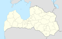
Garkalne is a village in Latvia 25 km northeast of the center of the capital Riga and namesake of the administrative unit of the same name (Lat .: Garkalnes novads ).
The place received a local council for the first time in 1945 and was raised to a municipality (lett. Pagast ) in 1990 through the addition of neighboring areas . The administrative center of today's district is located in Berģi , a suburb of Riga, the eastern part of which was separated from the city in 1977. In 2015 Garkalne had 1811 inhabitants.
The forests around Garkalne were home to extensive arms and ammunition stores for the Red Army , which have now fallen into disrepair. The area is under nature protection .
See also
literature
- Astrīda Iltnere (ed.): Latvijas Pagasti, Enciklopēdija. Preses Nams, Riga 2002, ISBN 9984-00-436-8 .
