
Gellert (Basel)

The Gellert is a district in the east of the St. Alban district in the city of Basel , in Switzerland .
The quarter is commonly counted as the most elegant and greenest district in Basel. In the 1860s, the Gellert Plateau became the city's first residential area after the old city wall was razed around St. Albantor , and afterwards the majority of the established Basel bourgeoisie settled in the lavishly designed parks and gardens. In this context, Gellertstrasse, named after the quarter, was previously referred to as Via Triumphalis Basel by the Basel art historian Jacob Burckhardt .
Although the quarter was increasingly characterized by larger housing estates, especially from the second half of the 20th century, when many of its stately villas and palaces were demolished, from a socio-economic perspective it can still be clearly assigned to the more upscale quarters of the city. In other Swiss cities, the district is comparable to the districts of Seefeld in Zurich , Champel in Geneva , or Kirchenfeld in Bern .
location
In a narrower sense, the Gellert district only extends from Karl Barth-Platz, Christoph Merian Platz and Bethesda Spital. In a broader sense, this also includes the Luftmatt residential area (summer casino, Sevogelplatz, St. Alban pond), which was mostly planned and built according to the same structures and dimensions.
history
After the city walls of Basel were razed in the 1860s, partly in order to enlarge the living space in the narrow inner city, the city opened up new, mostly undeveloped settlement areas. The city's first residential area was built on the Gellert plateau, on which Basel's gallows and, above all, numerous small vineyards were located in earlier centuries .
After the canton of Basel-Stadt was separated from the canton of Basel-Landschaft in 1833 , the canton of Basel-Stadt also had an increased interest in building a green residential area intended for wealthy citizens within its own, largely urban canton boundaries. This thinking was also based on the fact that any entries from the sale of land parcels should have been shared with the rural canton, which is why the creation of large, public parks was increasingly chosen as an alternative, which in turn encouraged the construction of larger private houses.
gallery

Historical photo of the Gellert quarter

The St. Albantor in the west of the Gellert

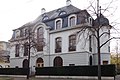
City palace on Hardstrasse

Neo-Gothic villa on Hardstrasse

Villa Barell, Hirzbodenweg

City palace, St. Alban plant

House on Wartenbergstrasse (Gellert in the broader sense)

Apartment block on Peter Merian Strasse (Gellert in the broader sense)

Villa on St. Jakobs-Strasse (Gellert in the broader sense)
Villa on St. Jakobsstrasse (Gellert in the broader sense)

Villa on Gellertstrasse

.jpg)


.jpg)

.jpg)
.jpg)


Web links
History and photographs of the St. Alban-Gellert Quartier Quartierverein St. Alban-Gellert
Individual evidence
- ↑ National information point on the NIKE CULTURAL HERITAGE - detailed view. Retrieved August 19, 2018 .
- ^ Lionel Gossman: Basel in the Age of Burckhardt: A Study in Unseasonable Ideas . University of Chicago Press, 2002, ISBN 978-0-226-30500-4 ( google.ch [accessed August 18, 2018]).
- ↑ Gellert Basel. Retrieved August 18, 2018 .
- ↑ Basel 1440: Geoadmin. (PDF) Federal inventory of places worth protecting in Switzerland, accessed on August 18, 2018 .
- ↑ The former monastery district. Retrieved August 19, 2018 .
- ^ Bernard Degen , Philipp Sarasin : Basel-Stadt. In: Historical Lexicon of Switzerland . May 30, 2017. Retrieved August 18, 2018 .
- ^ Lionel Gossman: Basel in the Age of Burckhardt: A Study in Unseasonable Ideas . University of Chicago Press, 2002, ISBN 978-0-226-30500-4 ( google.ch [accessed August 18, 2018]).