
Basel-St. Alban
|
Sankt Alban quarter of Basel |
|
|---|---|
 |
|
| Coordinates | 612700 / 266200 |
| surface | 2.94 km² |
| Residents | 11,534 (December 31, 2018) |
| Population density | 3923 inhabitants / km² |
| BFS no. | 2701-005 |
| Post Code | 4052 |
St. Alban , called Dalbe in Basel German , is a district of the city of Basel . It is located in Grossbasel on the south-eastern outskirts of the city and is shared by the districts of Breite ( St. Alban-Teich ), Bruderholz (Reinacherstrasse), Gundeldingen (train station area, Reinacherstrasse), Am Ring (Elisabethenanlage) and the suburbs (St. Alban-Anlage, Aeschengraben) limited.
The quarter is considered to be the most elegant and greenest district of Basel, as there are some residential areas (e.g. the so-called “ Gellertquartier ”) here. Most of the members of the noble and wealthy old Basel families lived in this district, as they do today.
description
The St. Alban's quarter is named after the former St. Alban's monastery . There is also the St. Alban Church ( Dalbekirche ), the St. Alban Gate ( Dalbedoor ) and the last piece of the Basel city wall in the St. Alban Valley ( Dalbeloch ) on the banks of the Rhine . St. Alban, which borders the Birs in the southeast, is traversed by the St. Alban-Teich Canal .
In the minds of many residents, the St. Alban is divided into several areas. On the one hand, in the west is the area around the SBB train station , which flows over into the so-called Aesche (the area around Aeschenplatz and Aeschenvorstadt). The area between St. Jacob's monument and the two bridges over the railway line is often referred to as Grosspeter (in the middle in the west). Towards the north you can very quickly reach the area that is now commonly referred to as the Gellert district. In the far east is St. Jakob . There is also the football stadium, the St. Jakob-Park , and also the St. Jakobshalle , the St. Jakob garden pool and the St. Jakob-Arena . However, only the football stadium is on urban soil, the rest belongs to the canton of Basel-Landschaft , municipality of Münchenstein . From St. Jakob to the south it goes up the mountain to the so-called Wolf. From there it goes to the southernmost tip of St. Alban, which is generally known as the tricorn. This is an industrial area, with a large part of it also belonging to the canton of Basel-Landschaft.
gallery

St. Albantor

Schöneck fountain, St. Alban-Vorstadt

Villa on Gellertstrasse

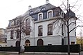
Christoph Merian Foundation
Villa on St. Jakobs-Strasse

Town house on Sevogelplatz

Villa on Hirzbodenweg (Gellert)

House for the new Kettenhof in the St. Alban suburb


.jpg)


Residential districts
St. Alban is divided into five residential districts:
- Gellert (Karl Barth-Platz, Christoph Merian-Platz, Bethesda-Spital)
- St. Jakob-Dreispitz (St. Jakob-Park stadium, Wolf freight yard , Dreispitz area)
- Luftmatt (summer casino, Sevogelplatz, St. Alban-Teich)
- Peter Merian (Rosenfeldpark, Gartenstrasse)
- Heumatt ( BIZ tower , Centralbahnplatz)
Buildings and landmarks
literature
- Anne Nagel, Esther Baur: St. Alban Valley in Basel. (Swiss Art Guide, No. 851/852, Series 86). Ed. Society for Swiss Art History GSK. Bern 2009, ISBN 978-3-85782-851-5 .
Web links
- Statistical Office of the Canton of Basel-Stadt - District portrait St. Alban
- Photos: image database of the canton of Basel-Stadt
Old Town Grossbasel | Old town of Kleinbasel | At the ring | Bachletten | Width | Bruderholz | Clara | Gotthelf | Gundeldingen | Hirzbrunnen | Iselin | Kleinhüningen | Klybeck | Matthew | Rose Valley | St. Alban | St. Johann | Suburbs | Wettstein