
Basel-Gotthelf
|
Gotthelf quarter of Basel |
|
|---|---|
 |
|
| Coordinates | 609.91 thousand / 267 182 |
| surface | 0.47 km² |
| Residents | 6936 (December 31, 2018) |
| Population density | 14,757 inhabitants / km² |
| BFS no. | 2701-009 |
| Post Code | 4054, 4055 |
Gotthelf is a district of the Swiss city of Basel . The Gotthelf-Quartier, the Gotthelfschulhaus and Gotthelfstrasse are named after Jeremias Gotthelf . It is located on the western outskirts and borders on the Iselin district in the north (Allschwilerstrasse, Ahornstrasse), in the west on the municipality of Allschwil ( canton Basel-Landschaft (Im Lange Loh)) and in the south on the Bachletten district (Wanderstrasse, Weiherweg) ; to the east is the Am Ring district (Spalenring and Spalentor ).
From a socio-economic perspective, the quarter is considered to be an upper middle class quarter , close to the city center, but with lots of green spaces.
Residential districts
Gotthelf is divided into two residential districts:
- Blauen (Allschwilerplatz, Ahornstrasse and Merian Iselin-Spital)
- Gottfried Keller (Morgartenring, Gotthelfplatz)
Buildings and landmarks
gallery

Row of houses on Palmenstrasse
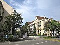
Crossing Ahornstrasse
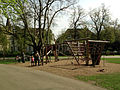
Border to the Schützenmattpark

Historical view of the Ahornstrasse


Web links
Individual evidence
- ^ A poem from a neighborhood: The Gotthelf Mittelstandviertel . In: bz Basellandschaftliche Zeitung . February 3, 2014 ( basellandschaftlichezeitung.ch [accessed on January 11, 2018]).
Old Town Grossbasel | Old town of Kleinbasel | At the ring | Bachletten | Width | Bruderholz | Clara | Gotthelf | Gundeldingen | Hirzbrunnen | Iselin | Kleinhüningen | Klybeck | Matthew | Rose Valley | St. Alban | St. Johann | Suburbs | Wettstein