
Basel Bachletten
|
Bachletten district of Basel |
|
|---|---|
 |
|
| Coordinates | 609869 / 266 502 |
| surface | 1.51 km² |
| Residents | 13'545 (31 December 2018) |
| Population density | 8970 inhabitants / km² |
| BFS no. | 2701-008 |
| Post Code | 4054 |
Bachletten is a district of Basel . It is located on the southwestern edge of the city and borders the Gotthelfquartier in the north (Wanderstrasse, Weiherweg) and in the northeast with the Quartier Am Ring (Steinenring, Viaduktstrasse ). In the east, the Birsig separates the quarter from Gundeldingen . To the west lies the community Allschwil , in the south Binningen (both Basel-Country ).
The Basel Zoo and the Schützenmatte are located in the Bachletten district . The playful name Bläächdalbe or Alumyyniumdalbe ( "sheet-St. Alban", "aluminum-St. Alban"), which for the Am Ring-Quartier applies, refers to the slightly less "noble" population compared with the Dalbe , the wealthy old Basel families in the St. Alban-Quartier (especially Gellert ), although from a socio-economic perspective the quarter is still one of the more upscale parts of the city.
The name "Bachletten" comes from the Bachlettenstrasse. With " Latvians " is clay-like soil is that at Birsig and on Rümelin Bach , often found, both the Bachletten-quarters by flowing rivers.
Residential districts
Bachletten is divided into five residential districts:
- Paulus (St. Paul's Church, Basel Zoo, Dorenbach Viaduct)
- Bernerring (Marschalkenstrasse, Rütimeyerplatz)
- Schützenmatt (Schützenmattpark, Wielandplatz, sports stadium)
- Holee (Holeestrasse, Laupenring)
- Weiherhof (hiking street, Steinbühlplatz, Neuweilerplatz)
Buildings and landmarks
- All Saints Church
- Pauluskirche
- Stephanuskirche
- Shooting mat with stadium shooting mat
- Neubad
- Basel Zoo
gallery

Pauluskirche

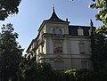
Apartment building in reform style "am Viadukt"
Corner house, Birsigstrasse

Schützenmattpark, meadow

Schützenmattpark, children's pool

The antelope house at Basel Zoo


.jpg)


Web links
Old Town Grossbasel | Old town of Kleinbasel | At the ring | Bachletten | Width | Bruderholz | Clara | Gotthelf | Gundeldingen | Hirzbrunnen | Iselin | Kleinhüningen | Klybeck | Matthew | Rose Valley | St. Alban | St. Johann | Suburbs | Wettstein