
Basel suburbs
|
Suburbs district of Basel |
|
|---|---|
 |
|
| Coordinates | 611 186 / 266 721 |
| surface | 0.90 km² |
| Residents | 5013 (December 31, 2018) |
| Population density | 5570 inhabitants / km² |
| BFS no. | 2701-002 |
| Post Code | 4051 |
The suburbs form a district of the Swiss city of Basel . They surround the city center of Grossbasel (Petersgraben, Leonhardsgraben, Kohlenberg, Steinenberg, St. Alban-Graben) and border on the outside in the north to the district of St. Johann (St. Johanns-Park), in the west to the Ring-Quartier (Johanniter- , Schanzenstrasse, Klingelbergstrasse and Schönbeinstrasse, Schützen- and Steinengraben, Heuwaage Viaduct ), in the south to the St. Alban district (St. Alban-Anlage, Aeschengraben) and in the east to the Breite district (" Dalbeloch ").
The suburbs emerged in the 15th century in Grossbasel as the construction of the outer Walls of Basel a large population growth took place in the formerly sparsely populated country outside the old wall. The suburban societies , which today belong to the traditional Basel corporations , also emerged during this period .
In the suburbs there used to be the city gates of the city wall , of which the Spalentor , St. Johanns-Tor and St. Alban-Tor are still preserved today. There are also a lot of museums in the suburbs.
Residential districts
The suburbs are divided into six residential districts:
- Albantal (Letziplatz, St. Alban-Tor)
- Alban (St. Alban-Vorstadt, St. Alban-Anlage)
- Aeschen (bank association, Elisabethenkirche, bulwark)
- Steinen (Steinenvorstadt, Music Academy, Holbeinplatz)
- Spalen (fire department, Spalentor)
- St. Johann and University (St. Peter's Square, Dance of Death, St. Johanns Gate)
Buildings and landmarks
Churches
Museums
- Architecture Museum Basel
- Swiss Fire Brigade Museum
- Museum of Contemporary Art
- Jewish Museum of Switzerland
- Cartoon Museum Basel
- Kunsthalle Basel
- Art Museum Basel
- Basel paper mill
- Toy Worlds Museum Basel
Other buildings
- University of Basel
- Basel University Library
- Bernoullianum
- St. Peter's Square
- Wildt's house
- Basel dance of death
- Music Academy of the City of Basel
- Theater Basel with Theaterplatz and Tinguely Fountain
- St. Alban's Monastery
- Leonhard High School
gallery

Spalentor

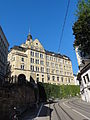
St. Peter's Square, villa

Side entrance to the college building of the University of Basel
Leonhard High School

Entrance to the Leonhardskirche


.JPG)
.JPG)

Web links
Old Town Grossbasel | Old town of Kleinbasel | At the ring | Bachletten | Width | Bruderholz | Clara | Gotthelf | Gundeldingen | Hirzbrunnen | Iselin | Kleinhüningen | Klybeck | Matthew | Rose Valley | St. Alban | St. Johann | Suburbs | Wettstein