Basel width
|
Broad quarter of Basel |
|
|---|---|
| Coordinates | 613 150 / 267 188 |
| surface | 0.68 km² |
| Residents | 8990 (December 31, 2018) |
| Population density | 13'221 inhabitants / km² |
| BFS no. | 2701-004 |
| Post Code | 4052 |
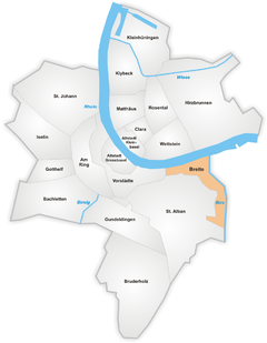
Breite , called Braiti in Basel German , is a district of the Swiss city of Basel . It is located at the eastern end of Grossbasel at the mouth of the Birs ( Birsköpfli ) and borders the Rhine in the north, the Birs and the neighboring Birsfelden in the east and the St. Alban district ( St. Alban-Teich ) in the south and west. . On the north-western edge at the St. Alban-Tor , the preserved piece of the Basel city wall forms the short border to the suburbs ; the southernmost point of the Breite district also borders the municipality of Muttenz .
The Breite-Quartier is named after the field name of a former open, flat field between the St. Alban-Quartier and the Birs estuary . As early as the 14th century , this field was known as "the width". From 1811 the road to Birsfelden and Zurich running there was called "Breite Strasse". After a new workers' settlement was built around the street in the 1850s, i.e. today's Breite-Quartier, the name of the street was changed to "Zürcherstrasse". A resident of the Breite-Quartier is known colloquially as a Braitlemer .
Residential districts
The width is divided into two residential districts:
- Lehenmatte (Lehenmattstrasse, Birsköpfli)
- Zürcherstrasse (Letziturm, Cécile Ines Loos facility)


