General Enrique Martínez
| General Enrique Martínez | ||
|---|---|---|
|
Coordinates: 33 ° 12 ′ S , 53 ° 48 ′ W General Enrique Martínez on the map of Uruguay
|
||
| Basic data | ||
| Country |
|
|
| Department | Treinta y Tres | |
| Residents | 1430 (2011) | |
| Detailed data | ||
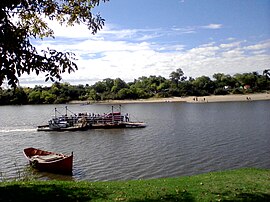
| Río Cebollatí with General Enrique Martínez | ||
General Enrique Martínez is a town in Uruguay .
geography
It is located in the department of Treinta y Tres in sector 2 on the banks of the Río Cebollatí on the border with the neighboring department of Rocha . A few kilometers east, downstream of the Cebollatí, lies the mouth of the Arroyo del Parao . Larger settlements near General Enrique Martínez are Villa Passano in the southwest and Arrozal Treinta y Tres in the northeast.
history
On October 15, 1963, General Enrique Martínez was classified in the " Pueblo " category by Law No. 13,167 . The village emerged as a settlement near a so-called Saladero ( salt meat factory ) located there at the time .
Infrastructure
education
General Enrique Martínez has a secondary school ( Liceo ) with the Liceo Rural Puerto La Charqueada, founded on April 24, 1989 .
Transport and infrastructure
The Ruta 91 leads through General Enrique Martínez . This is also where Ruta 17 ends , at whose kilometer point 54 is the only port on the Río Cebollatí, which originally served the trade with neighboring Brazil. In particular, jerky meat ( charque ) was exported, which is why the place is also known as La Charqueada . Crossing the river with the town of Cebollatí as the destination takes place in a motorized raft. This is not chargeable.
Nowadays, boat trips with the Stella Maris boat, which has a capacity of 25 passengers, are carried out from the port to the mouth of the Cebollatí in the Laguna Merín , around 25 kilometers away . Tourism plays a not insignificant role in General Enrique Martínez. There is a camping site with permanent huts near the shore. Agriculture and in particular rice cultivation, cattle breeding and fishing are additional sources of income on site.
Residents
General Enrique Martínez had 1,430 inhabitants at the 2011 census, of which 713 were men and 717 were women.
| year | Residents |
|---|---|
| 1963 | 922 |
| 1975 | 956 |
| 1985 | 979 |
| 1996 | 1,342 |
| 2004 | 1,513 |
| 2011 | 1,430 |
Source: Instituto Nacional de Estadística de Uruguay
Web links
- City map of General Enrique Martínez (PDF; 102 kB)
Individual evidence
- ↑ On some maps (e.g. OpenStreetMap) the place is also referred to as "La Charqueada".
- ^ A b Poblado General Enrique Martinez - La Charqueada - Departamento de Treinta y Tres (Spanish) on vergaraweb.com from August 2, 2011, accessed on July 16, 2017
- ↑ Liceos del Uruguay (Spanish) (PDF; 7.3 MB), accessed on February 29, 2012
- ↑ Statistical data from the Instituto Nacional de Estadística de Uruguay , accessed on September 23, 2012
- ↑ Statistical data of the Instituto Nacional de Estadística de Uruguay 1963–1996 (DOC; 47 kB)
- ↑ Statistical data from the Instituto Nacional de Estadística de Uruguay 2004 as XLS file

