Río Cebollatí
| Río Cebollatí | ||
|
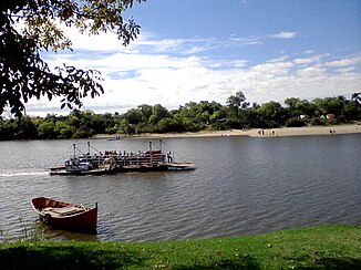
Ferry at the village of General Enrique Martínez ( La Charqueada ) |
||
| Data | ||
| location | South America , Uruguay | |
| River system | Río Cebollatí | |
| Drain over | Laguna Merín → Canal São Gonçalo → Lagoa dos Patos → Atlantic | |
| source | in the Cuchilla Cerro Partido | |
| muzzle |
Laguna Merín Coordinates: 33 ° 8 ′ 58 ″ S , 53 ° 37 ′ 25 ″ W 33 ° 8 ′ 58 ″ S , 53 ° 37 ′ 25 ″ W.
|
|
| length | 235 km | |
| Catchment area | 14,085 km² | |
The Río Cebollatí is a river in Uruguay .
The Cebollatí , part of the Laguna Merín basin , which is one of the longest rivers in Uruguay with a length of 235 km, has its source in the Cuchilla Cerro Partido in the Lavalleja department . On its route from southwest to northeast, it forms the border of the Rocha department with those of Lavalleja and Treinta y Tres . One of its tributaries is the Río Olimar . The Río Cebollatí finally flows into the Laguna Merín . The size of its catchment area is 14,085 km².
Web links
Commons : Río Cebollatí - collection of images, videos and audio files

