Rocky Mountain Geology
The geology of the Rocky Mountains comprises a rather heterogeneous mosaic of earth crusts ( terrans ), all of which have undergone independent geological development.
The Rocky Mountains owe their formation to intensive plate tectonic activity in the Mesozoic and Cenozoic . Over a period of around 130 million years, three major orogeny phases fundamentally reshaped western North America. The movements began around 170 million years ago in the Middle Jurassic and ended around 40 million years ago in the Middle Eocene . The Laramian orogeny , which lasted 70 to 40 million years, was the last of these three phases. She is responsible for uplifting the Rocky Mountains (on the order of around 2000 meters).
Forerunner - the "Ancestral Rocky Mountains" (300 million years ago)
The so-called "Ancestral Rocky Mountains" were an old Paleozoic mountain range of western North America, they were roughly at the point of today's southern Rocky Mountains in Colorado . This mountain range was formed around 300 million years ago during the Upper Carboniferous - roughly at the same time as the Variscan orogeny that took place in Europe, Eurasia and western North Africa . The uplift area of today's Colorado was largely covered by a shallow sea at that time. In the course of the orogenetic movements, two island-like high areas emerged, which geologists call Frontrangia and Uncompahgria - roughly identical to today's Front Range and the San Juan Mountains . They consisted mainly of Precambrian metamorphic rocks that, as a result of the tectonic movements, had made their way through the overlying sedimentary shell. The sediment cover mainly consisted of calcareous sediments that had been deposited in the Flachsee during the Paleozoic Era.
Development in the Mesozoic up to the Laramian orogeny (170 - 70 million years ago)
From the onset of tectonic movements in the second half of the Mesozoic Era , clods of differentiated earth crust were attached to the then western edge of the North American continent to a significant extent. These non-local terranes were brought up to the continental margin by or on the oceanic Farallon Plate , which subducted to the east , entered the subduction zone, but were not subduced due to their low density, but sheared off from the oceanic plate and attached to the continental margin (accreted). The terranes preferably represent island arcs (comparable to Japan, the Marianas or the Aleutian Islands) or small continents that emerged from previous island-arc-island-arc collisions.
The magma formed during the subduction process above the submerging oceanic crust in the upper mantle penetrated the continental crust of the North American continent inland to a distance of 300 to 500 kilometers. This created a large arched volcanic mountain range. Huge amounts of molten rock were intruded into deeper areas, where they slowly cooled and solidified into the large igneous bodies ( plutons ) that make up the Sierra Nevada today .
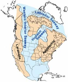
The sediments deposited in the area of the Rockies during the Mesozoic Era were marine, transitional and continental in nature; regionally and temporally they changed their character according to the prevailing crustal conditions. Up until the beginning of the Laramian movements, between 3000 and 4500 meters of sediment had been deposited, which was distributed over 15 geological formations . The greatest sediment thickness arose during the Cretaceous period , when the inlet of the Western Interior Seaway penetrated into the Rockies. The areas of origin of the deposited sediments are both the area of the arm of the sea and the volcanic arch of the "Ur-Sierra Nevada".
For more than 100 million years, the effects of the plate collisions were essentially limited to the edge of the North American Plate , far west of the actual Rocky Mountains. It was only 70 million years ago that they made themselves felt in the Rockies.
Emergence of the Rocky Mountains (70-40 million years ago)

The emergence of the Rocky Mountains is one of the most complex geological mysteries. Mountains are usually formed 200 to 400 kilometers behind a subduction zone , but the Rockies formed much further inland. The answer to this discrepancy may be found in a submerged oceanic plate anomaly.
At a typical subduction zone, the oceanic plate usually dips back into the mantle at a relatively steep angle and a volcanic island arc forms above the subducting plate. It is possible that this immersion angle was much flatter during the formation of the Rocky Mountains, so that the zone of magma formation and the associated orogenic movements were moved back much further into the hinterland than is normal. It is believed that the shallow dipping angle of the subducting plate increased frictional forces and other interactions with the thick continental crust mass above. Thrusts of enormous proportions stacked sheared crust layers on top of one another - the resulting isostatic emergence movements in turn made the Rocky Mountains rise to an extraordinarily wide and high mountain range.
The current Rockies were pushed by the remains of the former sedimentary shell ( Upper Carboniferous and Permian ) of the "Ancestral Rocky Mountains" as they rose. But also the sediments of the younger cover layers were partly spectacularly deformed, especially at the edges of the individual mountain ranges where they were steeply set up. An example of this is the Dakota Hogback , a sandstone formation from the Lower Cretaceous, which accompanies the entire east side of the modern Rockies with high angles of incidence.
See also
Individual evidence
- ↑ a b c d e f g Geologic Provinces of the United States: Rocky Mountains . In: USGS Geology in the Parks . Archived from the original on May 13, 2008. Info: The archive link was inserted automatically and has not yet been checked. Please check the original and archive link according to the instructions and then remove this notice. Retrieved December 10, 2006. (public domain source)
- ^ Halka Chronic: Roadside Geology of Colorado 1980.


