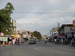
Gerona (Tarlac)
| Municipality of Gerona | ||
| Location of Gerona in the province of Tarlac | ||
|---|---|---|

|
||
| Basic data | ||
| Region : | Central Luzon | |
| Province : | Tarlac | |
| Barangays : | 44 | |
| District: | 2. District of Tarlac | |
| PSGC : | 036906000 | |
| Income class : | 1st income bracket | |
| Households : | 15,769 May 1, 2000 census
|
|
| Population : | 87,531 August 1, 2015 census
|
|
| Population density : | 679.1 inhabitants per km² | |
| Area : | 128.89 km² | |
| Coordinates : | 15 ° 36 ′ N , 120 ° 36 ′ E | |
| Postal code : | 2302 | |
| Mayor : | Dennis Norman T. Go | |
| Website: | http://gerona.gov.ph/ | |
| Geographical location in the Philippines | ||
|
|
||
Gerona is a metropolitan parish in the Province of Tarlac on the island of Luzon in the Philippines . It has 87,531 inhabitants (August 1, 2015 census) who live in 44 barangays . It belongs to the 1st income bracket of the communities in the Philippines.
Its neighboring parishes are Tarlac City in the south, Pura parish in the east, Paniqui parish in the north, and Santa Ignacia parish in the west.
The community is located approximately 14.4 km north of Tarlac City and approximately 139 km northwest of the Philippine capital Manila and can be reached from there via the Mc Arthur Highway.
Barangays
|
|
|
swell
- Website of the municipality of Gerona
- Information on Gerona from the Philippine Statistics Agency
- Gerona on tarlacprovince.com
Web links
Commons : Gerona, Tarlac - collection of images, videos and audio files

