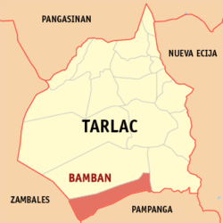
Bamban (Tarlac)
| Municipality of Bamban | ||
| Location of Bamban in the province of Tarlac | ||
|---|---|---|

|
||
| Basic data | ||
| Region : | Central Luzon | |
| Province : | Tarlac | |
| Barangays : | 15th | |
| District: | 3. District of Tarlac | |
| PSGC : | 036902000 | |
| Income class : | 2nd income bracket | |
| Households : | 9113 May 1, 2000 census
|
|
| Population : | 69,466 August 1, 2015 census
|
|
| Population density : | 69466 / 251.98 inhabitants per km² | |
| Area : | 251.98 km² | |
| Coordinates : | 15 ° 39 ′ N , 120 ° 15 ′ E | |
| Postal code : | 2317 | |
| Geographical location in the Philippines | ||
|
|
||
Bamban is a metropolitan parish in the province of Tarlac on the island of Luzon in the Philippines . It has 69,466 inhabitants (August 1, 2015 census) who live in 15 barangays . She belongs to the 2nd income bracket of the communities in the Philippines. It borders in the south on the province of Pampanga , in the east on the municipality of Concepcion , in the north on the municipality of Capas and in the west on the province of Zambales . It is located about 26 km south of Tarlac City and about 93 km northwest of the Philippine capital Manila and can be reached from there via the Mc Arthur Highway.
Barangays
|
|
