
Capas
| Municipality of Capas | |||
| Location of Capas in the province of Tarlac | |||
|---|---|---|---|

|
|||
| Basic data | |||
| Region : | Central Luzon | ||
| Province : | Tarlac | ||
| Barangays : | 20th | ||
| District: | 3. District of Tarlac | ||
| PSGC : | 036904000 | ||
| Income class : | 1st income bracket | ||
| Households : | 18,333 May 1, 2000 census
|
||
| Population : | 140.202 August 1, 2015 census
|
||
| Population density : | 372.5 inhabitants per km² | ||
| Area : | 376.39 km² | ||
| Coordinates : | 15 ° 21 ′ N , 120 ° 28 ′ E | ||
| Postal code : | 2315 | ||
| Geographical location in the Philippines | |||
|
|||

Capas is a metropolitan parish in the province of Tarlac on the island of Luzon in the Philippines . It has 140,202 inhabitants (August 1, 2015 census) who live in 20 barangays . It belongs to the 1st income bracket of the communities in the Philippines. Their neighboring communities are Tarlac City , San Jose (Tarlac) in the north, Concepcion in the east, Botolan in the west and Bamban in the south. It is located approx. 18.3 km south of Tarlac City and approx. 107 km northwest of the Philippine capital Manila and can be reached from there via the Mc Arthur Highway.
In the Barangay O'Donnell, the Capas National Shrine (Paggunita Sa Capas) was inaugurated in 1991 by the then President Corazon Aquino . It commemorates the Bataan death march of American and Filipino soldiers in 1942. Every year on April 9, a memorial service is held in honor of the dead.
Barangays
|
|
swell
- The municipality of Capas on tarlacprovince.com
- Information on Capas from the Philippine Bureau of Statistics

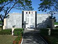
The Death Marsh Memorial in the Capas National Shrine

