Zambales
| Basic data | |
|---|---|
| Region : | Central Luzon |
| Capital : | Iba |
| Population : | 590,848 August 1, 2015 census
|
| Population density : | 167 inhabitants per km² |
| Area : | 3,529.4 km² |
| PSGC : | 037100000 |
| Governor : | Hermogenes E. Ebdane, Jr. |
| Official website: | official website of the province |
| structure | |
| - Highly urbanized cities | 1 |
| - provincial cities | |
| - municipalities | 13 |
| - Barangays | |
| - electoral districts | 2 |
| Location of the province in the Philippines | |

|
|
Coordinates: 15 ° 20 ′ N , 120 ° 10 ′ E Zambales is a province on the island of Luzon in the Philippines . It belongs to the Central Luzon administrative region . The capital of the province is Iba , the population is 590,848 (August 1st 2015 census) people living in 13 municipalities. The city of Olongapo City is an autonomous county-level city .
geography
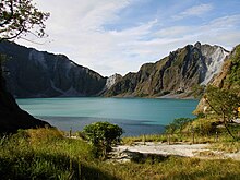
The area of the province covers 3,529.4 km² and is located on the west coast of the island of Luzon on the South China Sea . Its neighboring provinces are Pangasinan in the north, Tarlac and Pampanga in the east and Bataan in the south. The mountain range of the Zambales Mountains dominates the topography of the province, the coastal strip is relatively narrow. The highest mountain is Mount Tapulao , 2037 meters high , also known as the High Peak. The most famous mountain in the province is the Pinatubo volcano , which after its huge eruption in 1991 only reached a height of 1,486 meters above sea level. There are numerous small islands off the coast of the province, such as San Salvador Island .
history
Little is known about the history of the province in the pre-colonial era; mainly the orally transmitted stories of the people of the Aeta and the Negritos provide information. The myths of the indigenous people of the Negritos indicate that their origin is linked to the island of Sulawesi . It can be assumed that trade contacts with the states in East and Southeast Asia have existed since the first millennium . The city of Tondo in the Bay of Manila was founded as early as the 9th century, and the Arab traveler Ibn Battuta reported on his trip to China in the 14th century about his stay in the land of Tawalisi and the princess Urduja , which many scientists did in Pangasinan to the north locate.
The Spanish conquistador Juan de Salcedo was the first European to reach the province in 1572 and reports of pristine landscapes that are overgrown with thick vegetation . The first municipalities were established at the beginning of the 17th century. There is evidence that Masinloc, Iba and Santa Cruz were founded in 1607, 1611 and 1612. Masinloc was also the first capital of the province before the more strategically located city of Iba became the capital of the province. The name Zambales comes from the Malay language and was pronounced Zambal, the Spanish conquerors used this name for the region since their arrival.
Attractions
The Magsaysay Ancestral House is located in Castillejos and is the home of the third President of the Philippines Ramon Magsaysay , it now houses a small museum that provides information about the President and his family. The Looc Lake is also located in the municipality of Castillejos and is located in an unspoilt nature that presents the visitor with the pristine nature of Zambales. Aanawangin Bay is located in the municipality of San Antonio and has one of the longest sandy beaches in the province. The San Augustine Church in Iba is considered to be one of the most beautiful churches in the province, and the San Andres Church in Masinloc is one of the oldest church buildings in the province of Zambales, the parish was founded as early as 1607. Kitsie's Crocodiles Farm in the municipality of Botolan presents rare species of animals from the Philippines, such as the rare Philippines crocodile . The main tourist attraction of the province is the Pinatubo volcano with its crater lake. The highest mountain in the province, Mount Tapulao, is accessible via hiking trails and offers a breathtaking panoramic view over the Zambales Mountains. In the south of the province is the Subic Watershed Forest Reserve .
Administrative division
Cities
- Olongapo City , autonomous county-level city
Boroughs
- Subic
- Castillejos
- San Marcelino
- San Antonio
- San Narciso
- San Felipe
- Cabangan
- Botolan
- Iba
- Palauig
- Masinloc
- Candelaria
- Santa Cruz


