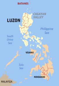
Batanes
| Basic data | |
|---|---|
| Region : | Cagayan Valley |
| Capital : | Basco |
| Population : | 17,246 August 1, 2015 census
|
| Population density : | 79 inhabitants per km² |
| Area : | 219.01 km² |
| PSGC : | 020900000 |
| structure | |
| - Highly urbanized cities | |
| - provincial cities | |
| - municipalities | 6th |
| - Barangays | |
| - electoral districts | 1 |
| Location of the province in the Philippines | |

|
|
Coordinates: 20 ° 35 ' N , 121 ° 54' E
Batanes is the northernmost and smallest province in the Philippines . It consists of the - almost eponymous - archipelago of the Batan Islands . The capital of the province is Basco . A total of 17,246 inhabitants ( August 1, 2015 census ) live on the islands, which have an area of 219.01 km².
geography
The Batanes Province is part of the Cagayan Valley region , which is predominantly located on the main island of Luzon .
The Batan Islands lie on the Luzon Strait and are separated from the Babuyan Islands by the Balintang Canal and from Taiwan by the Bashi Strait .
The archipelago includes the following islands (from north to south):
- Y'Ami
- North Island
- Mabudis Island
- Maysanga (Misanga)
- Siayan Island (Stayan)
- Itbayat Island , inhabited
- Diogo Island
- Batan , the main inhabited island
- Sabtang , inhabited
- Ivuhos (Ibuhos, Ibahos, Vohas)
- Deqeu (Diadekey)
- Balintang
There are also some very small unnamed secondary islands and rocks. Only the three largest of the Batan Islands are inhabited: the main island of Batan, Itbayat and Sabtang.
People and culture
The native people in the province are called Ivatan . In terms of their physical appearance and culture, they are more closely related to the indigenous peoples of Taiwan than to the Filipino peoples. The most widely used language in the province is the Austronesian Ivatan .
Communities
The province of Batanes has 6 municipalities, which in turn are divided into 29 barangays .
Municipalities of the province (the first four are on the main island of Batan, while Itbayat and Sabtang consist of the islands of the same name and uninhabited neighboring islands):
history
The ancestors of today's Ivatan people were Austronesians who settled the Batan Islands 4000 years ago during the Neolithic period. They lived mainly in mountain dwellings, so-called Idjangs, and used gold as their currency. They also created an agriculture-based industry. They were also seafarers and shipbuilders. Between the 6th century and the 10th century, the Chinese came to the islands to trade. Remains of Chinese porcelain have been discovered on Batan Island.
In 1687, the captain William Dampier drove to the islands with a team of English and Dutch privateers and named them after the country's monarchs. Itbayat was named Orange Island in honor of King William III. of Orange-Nassau and Batan became Grafton Isle . Sabtang ( Monmouth Isle ) was named after James Scott, 1st Duke of Monmouth. Captain Dampier stayed almost three months and did not claim any of the islands for the English crown.
In 1783 the Spaniards claimed the province as part of the Philippines under the patronage of Governor General Jose Basco y Vargas. The Ivatans, however, stayed in their Idjangs. In 1790, Governor Guerrero ordered the Invatans to live in the lowlands, creating the first two cities of Basco and Ivana. The Spaniards also built limestone bridges at that time, some of which are still standing. In 1890, attention was drawn to the Ivantan because they were considered the home of the revolutionary ideas of the Katipunan, a Philippine secret society. The Ivatan of this secret society, who were not satisfied with the Spanish rule, killed the ruling General Fortea and declared Spanish rule over.
Many public schools sprang up during the colonization of America. In 1920 the first wireless telegraph was installed and in 1930 a smaller airfield was built. Roads were built and Batanes High School was founded.
In World War II, many Ivatan-men were executed by the Japanese. The Japanese also sexually molested and raped the Ivatan women. When the US regained the country, Batanes became a province again.
In 2004, Vicente S. Gato was elected Governor of Batanes.
Web links
- Official website of the province ( Memento of January 3, 2007 in the Internet Archive ) (English)
- Further information with many pictures ( Memento from September 9, 2006 in the Internet Archive )
