Itbayat
| Municipality of Itbayat | ||
| Location of Itbayat in the Batanes Province | ||
|---|---|---|

|
||
| Basic data | ||
| Region : | Cagayan Valley | |
| Province : | Batanes | |
| Barangays : | 5 | |
| District: | 1. District of Batanes | |
| PSGC : | 020902000 | |
| Income class : | 5th income bracket | |
| Households : | 719 May 1, 2000 census
|
|
| Population : | 2,867 August 1, 2015 census
|
|
| Population density : | 34.5 inhabitants per km² | |
| Area : | 83.13 km² | |
| Coordinates : | 20 ° 47 ′ N , 121 ° 50 ′ E | |
| Postal code : | 3905 | |
| Geographical location in the Philippines | ||
|
|
||
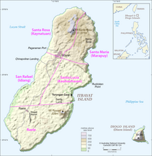
Itbayat is the northernmost Filipino borough . It belongs to the province of Batanes . On August 1, 2015, the community had 2867 inhabitants. In addition to Itbayat Island , the administrative area of the municipality also includes five named islands , all of which with one exception are north of the main island and are therefore the northernmost islands of the Philippines, as well as a few small unnamed minor islands and rocks. The islands from north to south:
- Y'Ami Island
- North Island
- Mabudis Island
- Maysanga (Misanga)
- Siayan Island (Stayan)
- Diogo Island
Barangays
|
The municipality of Itbayat is divided into five barangays (population at the 2000 census in brackets)
|

Division of the island into barangays
|
Individual evidence
- ^ Region II - Cagayan Valley ( Memento from January 30, 2010 in the Internet Archive )
